 Vietnamnet.vn

 Podcast



A tropical depression near the East Sea has strengthened into a storm internationally named Noul. The storm is forecast to enter the East Sea late tonight or early Saturday (July 25), becoming the second storm to affect the sea this year.
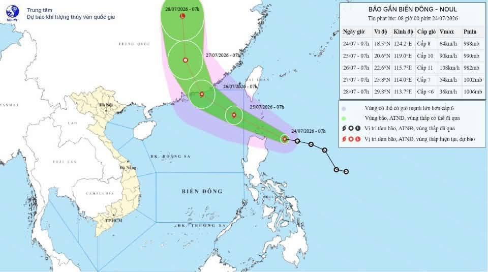
According to the National Center for Hydro-Meteorological Forecasting (NCHMF), the tropical depression strengthened into Tropical Storm Noul overnight on July 23. It is the 12th storm to form over the northwestern Pacific this year.
Noul is forecast to enter the northeastern waters of the northern East Sea late tonight or early Saturday (July 25), becoming the second storm to enter the East Sea in 2026.
The storm is then expected to continue toward Guangdong province in China, with an estimated 80% probability of making landfall there on July 26. It is considered unlikely to directly affect Vietnam’s mainland.
As of 7 a.m. on July 24, the storm’s center was located at approximately 18.3 degrees north latitude and 124.2 degrees east longitude, about 210 kilometers east of Luzon Island in the Philippines.
Maximum sustained winds near the center were at Level 8, or 62-74 kph, with gusts reaching Level 10. The storm was moving west-northwest at around 25 kph.
Over the next 24 hours, Noul is forecast to continue moving west-northwest at 25 kph and could strengthen further. By 7 a.m. on July 25, its center is expected to be over the northeastern waters of the northern East Sea, with winds strengthening to Levels 9-10 and gusts reaching Level 12.
El Nino 2026-2027 outlook: Extreme heat and abnormal floods
Over the following 24 hours, the storm is expected to maintain its west-northwest track at around 15-20 kph and continue intensifying.
By 7 a.m. on July 26, its center is forecast to be over coastal waters off Guangdong province, China, with winds at Levels 10-11 and gusts reaching Level 13.
During the next 24 hours, Noul is forecast to change direction and move north-northwest at 15-20 kph while gradually weakening into a tropical depression.
By 7 a.m. on July 27, the center of the tropical depression is expected to be over land in Guangdong province, with winds weakening to Level 7 and gusts at Level 9.
Between 72 and 96 hours from now, the tropical depression is forecast to move mainly northward at 15-20 kph and gradually weaken into a low-pressure area.
Under the influence of Noul, winds over the northeastern waters of the northern East Sea are forecast to strengthen to Levels 6-7 from the evening of July 24, later increasing to Levels 8-9, with waves of 3-5 meters.
Near the storm’s center, winds could reach Levels 10-11, with gusts at Level 13 and waves of 4-6 meters. Seas are expected to be extremely rough.
Vessels operating within the affected areas could face thunderstorms, tornadoes, strong winds and high waves.
Bao Anh
.svg)
