Once inside the East Sea, the storm is forecasted to move swiftly at around 20 km/h, peaking at levels 16-17 with gusts beyond level 17 between September 22 and 23. Dr. Lam noted that this intensity would match that of Typhoon Yagi (Storm No. 3) in 2024.
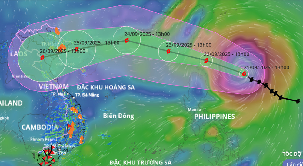
By September 24, Ragasa is expected to weaken and pass over China’s Leizhou Peninsula in the early hours of September 25, entering the Gulf of Tonkin with winds at levels 12-14 and gusts up to 15-16.
Forecasts indicate that the storm will make landfall in Vietnam on September 25, with its main trajectory covering the region from Quang Ninh to Ha Tinh.
Two forecast scenarios emerge
Dr. Lam explained that in recent days, multiple forecasting models from both Vietnamese and international meteorological centers have consistently shown Ragasa as an extremely intense storm with a vast wind circulation, potentially becoming the most powerful typhoon to enter the East Sea in 2025.
According to Japan’s Meteorological Agency, Ragasa’s maximum sustained wind speeds may reach 195 km/h (level 16), with gusts exceeding level 17. China’s meteorological authority expects winds up to 223 km/h, while the Hong Kong Observatory forecasts 240 km/h, all surpassing level 17.
By September 24, as the storm approaches Guangdong Province, interaction with terrain and northern friction is expected to weaken Ragasa by two to four levels before it enters the Gulf of Tonkin.
However, Dr. Lam warned that a worse-case scenario is still possible: if Ragasa follows a more westerly track, it could maintain stronger winds due to less weakening, increasing the intensity of wind and wave impacts in the Gulf.
“In this scenario, strong storm winds and heavy rain could affect northern coastal provinces and areas from Thanh Hoa to Hue,” Dr. Lam noted.
Adding complexity to the situation is an early-season cold front approaching from the north. The interaction between this cold air mass and Ragasa could alter the storm’s trajectory and strength in the coming days, making long-range forecasts (beyond 3 days) less reliable.
Even a shift of 50-100 km north or south could significantly affect the storm’s intensity and impacts. Therefore, experts stress the importance of closely monitoring updated forecasts based on observational data.
Early warnings for ships and coastal zones
Meteorologists emphasized the need for immediate caution regarding high winds and dangerous sea conditions, especially for maritime operations.
Starting September 22, the northern East Sea (including the Paracel Islands) will face winds of levels 8-9, later intensifying to levels 10-14. Areas near Ragasa’s eye could experience winds of levels 15-17 with gusts exceeding level 17 and wave heights above 10 meters. These conditions are extremely hazardous, even for large vessels.
From September 24, the Gulf of Tonkin (including Con Co, Bach Long Vi, and Co To islands) will see wind levels of 8, increasing to 11-13 near the storm's center, with gusts at 15-16. Thunderstorms, waterspouts, and very rough seas are likely.
By early September 25, nearshore areas from Quang Ninh to Ha Tinh are expected to see winds of levels 7-8, strengthening to 9-10. Areas close to the storm center could experience levels 12-14, with gusts at 15-16 and wave heights of 4-7 meters.
Aquaculture cages, moored boats, and fishing fleets in these areas face high risks from strong winds and waves, particularly in the projected landfall zone.
Meteorological agencies also warned of thunderstorm activity and tornadoes when the typhoon is still 300-400 km offshore. Coastal areas from Quang Ninh to Hue and Da Nang are advised to remain alert for tornadic conditions on the storm’s leading edge.
Bao Anh