Typhoon No. 6 (Trami) currently affects the coastal areas of Thua Thien Hue and Da Nang, bringing winds up to level 12. The storm is expected to move inland in this region before turning back to the sea and weakening.
According to the National Center for Hydro-Meteorological Forecasting, Typhoon Trami has brought strong winds across several areas. Con Co Island (Quang Tri) recorded winds at level 8, gusting to level 9; Cu Lao Cham Island (Quang Nam) recorded level 8, gusting to level 10; Ly Son Island (Quang Ngai) experienced level 6 winds, gusting to level 7; Nam Dong (Thua Thien Hue) had level 8 winds, gusting to level 10; and Cam Le (Da Nang) recorded level 8 winds, gusting to level 9.
Heavy rains also struck areas from Ha Tinh to Da Nang overnight and this morning (October 27), with rainfall ranging from 100-200 mm, reaching over 350 mm in some places.
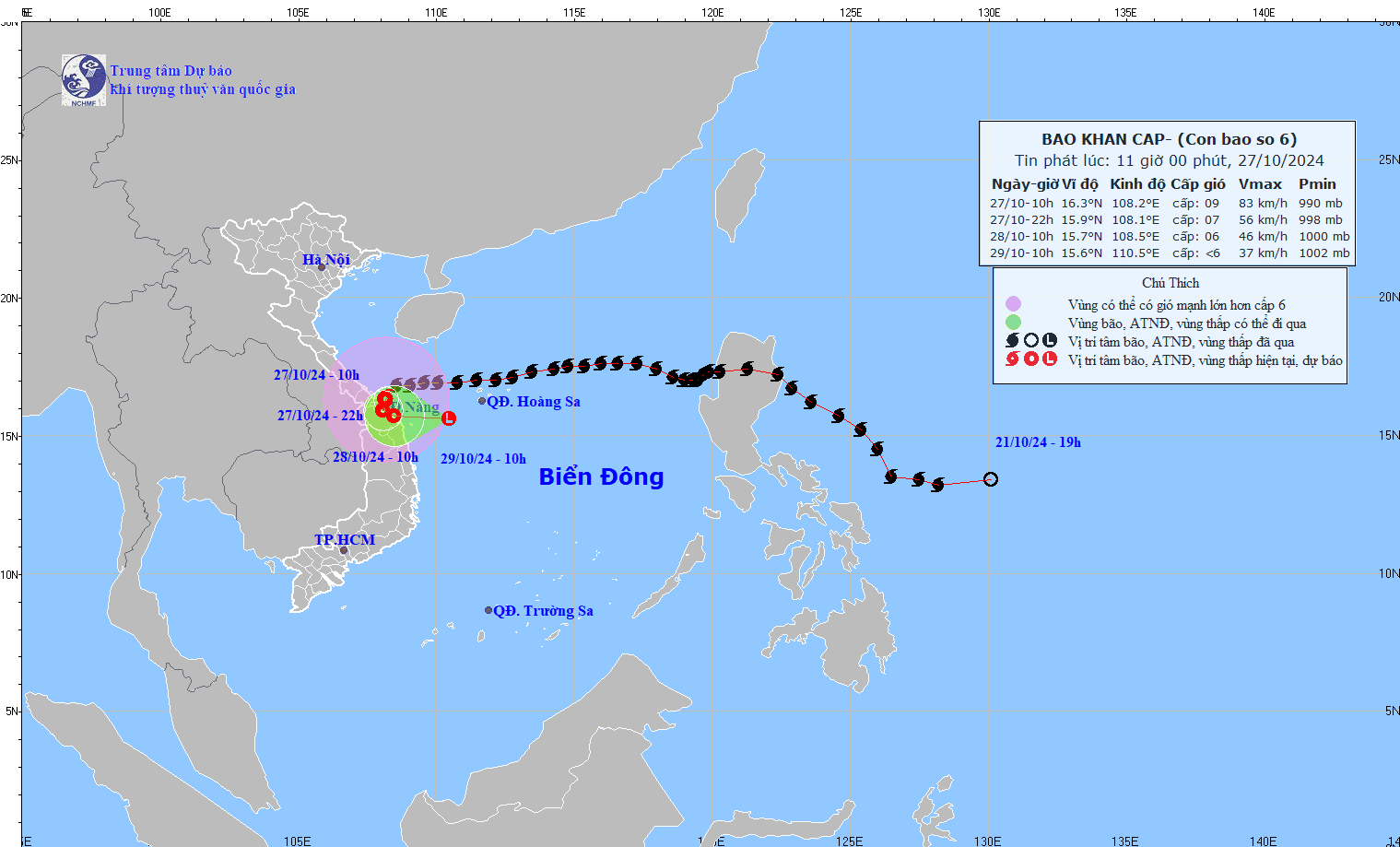
As of 10 AM today, Typhoon Trami’s center was positioned off the coast of Thua Thien Hue and Da Nang, with maximum winds reaching level 9 (75-88 km/h), gusting up to level 12. The storm was moving southwest at a speed of 15-20 km/h.
Over the next 12 hours, the storm will shift directions to move south-southwest. By 10 PM, the storm is expected to weaken to level 7 winds, gusting to level 10, and continue moving at around 5 km/h as it transitions into a tropical depression.
By 10 AM on October 28, the tropical depression will be near the coast between Thua Thien Hue and Quang Ngai, moving eastward at 3-5 km/h, with winds of level 6, gusting to level 8.
Within 24 hours, the depression is expected to continue moving eastward at 5-10 km/h, reaching the southwestern waters of the Hoang Sa Archipelago by 10 AM on October 29. By 7 PM on October 29, it will have moved further east, with winds of level 6, gusting to level 8, south of the Hoang Sa Archipelago.
Due to Typhoon Trami’s circulation, seas off Quang Binh to Quang Ngai, including Con Co, Cu Lao Cham, and Ly Son Islands, will experience strong winds at level 6-7, near the typhoon center at level 8-9, gusting to level 11, and waves reaching 3-5 meters, making conditions very rough.
Coastal areas from Quang Binh to Quang Nam are also at risk of storm surge, with sea levels potentially rising by 0.4-0.6 meters.
Boats and ships operating along the coast from Quang Binh to Quang Ngai are likely to face thunderstorms, whirlwinds, strong winds, and large waves.
The risk of erosion is high for coastal dikes from Quang Tri to Quang Nam due to large waves and storm surge.
Onshore, areas from Quang Binh to Quang Nam will experience strong winds at level 6-7, gusting to level 8-9, with winds reaching levels 8-9, gusting to level 11 near the storm’s center. From today through the night of October 28, the region can expect heavy to very heavy rainfall of 200-400 mm, with isolated areas exceeding 600 mm. Localized heavy rainfall with intensities above 100 mm per three hours is also forecasted. Additionally, Ha Tinh, Quang Ngai, Binh Dinh, and northern Central Highlands may see heavy rain, with some areas receiving 100-200 mm, and isolated places exceeding 250 mm.
Typhoon Trami’s progression remains complex and could change; residents are advised to stay updated with upcoming storm alerts.
Bao Anh