Typhoon Yagi, currently active east of Luzon Island, Philippines, is gaining strength and expected to enter the East Sea by tomorrow evening, potentially escalating into a very severe storm.
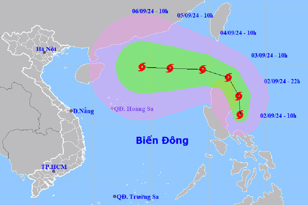
According to the National Center for Hydro-Meteorological Forecasting on September 2nd, Typhoon Yagi is currently located in the waters east of Luzon Island. As of 10 AM, the typhoon's center was positioned with maximum sustained winds of 62-74 km/h (force 8), and gusts reaching up to 102 km/h (force 11). Yagi is moving in a northwest direction at approximately 20 km/h.
The forecast indicates that within the next 24 hours, Yagi will maintain its current speed and move in a west-northwest direction, with an increasing intensity. By 10 AM tomorrow (September 3rd), the storm is expected to be situated over the northeastern waters off Luzon Island, with maximum sustained winds of 75-88 km/h (force 9) and gusts over 118 km/h (force 12). The eastern part of the northern East Sea will be under its influence, with a disaster risk level of 3.
In the 24 to 48 hours following that, Yagi is projected to move westward at a speed of about 10 km/h, continuing to strengthen as it enters the East Sea.
By 10 AM on September 4th, Yagi's center is expected to have sustained winds of 89-102 km/h (force 10) with gusts of up to 118 km/h (force 12). The eastern part of the northern East Sea will again be under its influence, with the disaster risk level remaining at 3.
Looking ahead to September 5th, the typhoon is expected to continue its westward trajectory at approximately 15 km/h, with maximum sustained winds of 103-117 km/h (force 11) and gusts up to 133-150 km/h (force 14). This will pose a significant threat to the northern parts of the northern East Sea, with a sustained disaster risk level of 3.
Meteorologists predict that from September 4th to 6th, Typhoon Yagi could reach a very intense level over the northeastern part of the East Sea, with maximum wind speeds potentially reaching force 12 and gusts up to force 15 near the storm’s center.
During the next 24 hours, the eastern part of the northern East Sea will experience waves ranging from 2 to 4 meters. From September 4th to 6th, wave heights could increase to 5 to 7 meters, creating extremely dangerous conditions for vessels.
"Starting from the afternoon and evening of September 3rd, Typhoon Yagi will enter the East Sea. From September 3rd, winds in the northeastern waters of the northern East Sea will gradually strengthen to force 6, with areas near the storm's center reaching force 8 and gusts over force 11. The sea will become extremely rough and dangerous for maritime activities," the meteorological agency warned.
Bao Anh