On the afternoon of September 18, Deputy Minister of Agriculture and Rural Development, Nguyen Hoang Hiep, chaired a meeting with various ministries and agencies, along with an online conference involving 11 coastal provinces from Ninh Binh to Binh Dinh, to prepare for the tropical depression, which may intensify into a storm.
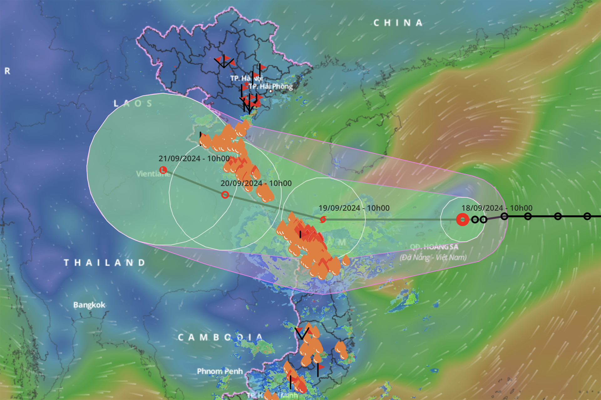
During the meeting, Dr. Mai Van Khiem, Director of the National Center for Hydro-Meteorological Forecasting, stated that by 1pm on September 18, the tropical depression was located about 530km east of Da Nang, moving slowly at 15km/h.
“All weather models, both domestic and international, indicate that the tropical depression could strengthen into a storm,” Dr. Khiem explained.
The forecast suggests that by 10am on September 19, the tropical depression will intensify into a storm with wind speeds reaching level 8 and gusts up to level 10. The storm's center is expected to be located about 110km east-southeast of Quang Tri and Quang Nam, before making landfall later in the day and weakening as it moves inland.
The projected high tides at the time of landfall (from 5pm on September 19 to 7am on September 20) are expected to reach 0.7-1.8 meters at Cua Gianh (Quang Binh), 0.7-1.4 meters at Cua Viet (Quang Tri), and 0.7-1.3 meters in Da Nang.
From September 17 to midday on September 18, the central and Central Highlands regions experienced significant rainfall ranging from 50-150mm, with some areas recording higher levels, such as Bach Ma (237mm) and Suoi Da (279mm) in Da Nang.
It is forecasted that from the evening of September 18 through September 19, heavy rain will continue from Ha Tinh to Quang Ngai, with rainfall totals ranging from 100-300mm and some areas exceeding 500mm. Meanwhile, Thanh Hoa and Nghe An are expected to receive 70-150mm of rain, with isolated areas reaching over 250mm, and the Central Highlands will see 40-80mm of rain, with some spots exceeding 150mm.
From September 18 to 21, rivers from Thanh Hoa to Quang Nam are predicted to experience a flood wave, with water levels rising by 3-7 meters. Major rivers such as the Ma River and Buoi River in Thanh Hoa, and the Ca River in Nghe An, are expected to rise to levels between the first and second flood alert, while smaller rivers in Quang Binh and Quang Tri may reach the third flood alert.
Low-lying areas along rivers, particularly from Thanh Hoa to Quang Nam, face a high risk of flooding, and mountainous areas are at risk of landslides.
The Border Guard Command reported that as of 11 AM on September 18, authorities had contacted and informed 66,960 boats and 306,725 people of the tropical depression’s development and its likely path, allowing them to take precautions. Among these, 75 boats with 618 people were operating near the Hoang Sa Archipelago.
The Department of Fisheries also reported that by 1 PM on September 18, 80,024 hectares of coastal and offshore aquaculture facilities were at risk, along with 22,152 cages and 684 watchtowers.
Colonel Pham Hai Chau, Deputy Director of the Rescue Department, noted that over 268,000 people, including 56,000 military personnel, 211,000 militia members, and more than 4,000 vehicles, as well as 10 helicopters, are ready to respond to the tropical depression and any potential storm, ensuring the safety of residents and providing emergency aid.
He also emphasized the need to review areas prone to landslides, citing previous experiences where damage was minimal from storms but significantly increased during post-storm downpours and subsequent landslides.
“There must be a quick and efficient warning system for households in landslide-prone areas, ensuring that people can relocate to safety in a timely manner,” Colonel Chau stressed.
Dinh Hieu