


Along with Ngang Pass, Gianh River is a geographical symbol of the central province of Quang Binh. The river is 160 km long, originating from the 2,017m Co Pi mountain in the Truong Son range. The Gianh River flows through the districts of Minh Hoa, Tuyen Hoa, Quang Trach, and Bo Trach to the East Sea. Photo: Tran An

Han River has its literal name “Han Giang”. During the French colonial period, it was also known as the Da Nang River. The Han River in Da Nang begins at the confluence of the river, where the confluence between Cam Le and Vinh Dien rivers is also bordered by two districts of Cam Le and Ngu Hanh Son.
The river flows in a south-north direction, passing through city center and then flows into Danang Bay with a length of about 7.2km. The width of the river is about 900 – 1,200m, and the average depth of 4 – 5m is the waterway traffic junction connecting with the districts of Ngu Hanh Son, Cam Le, Hoa Vang district and the districts of Quang Nam province. Photo:
Photo: Huynh Nam Dong

Lam River is 361 km long, one of the two largest rivers in the North Central region. Along with Hong Linh mountain, Lam river is considered a symbol of Nghe An and Ha Tinh province. On both sides of the river, there are cultural villages such as Yen Ho (Duc Tho), Tien Dien, Uy Vien (Nghi Xuan), Trung Luong (Hong Linh town), Trung Can, Hoanh Son, Kim Lien (Nam Dan). Photo: Nguyen Anh Duc.

Dau Tieng Lake, with an area of 27,000 hectares, is the largest artificial lake in Vietnam, located in the three provinces of Tay Ninh, Binh Duong, and Binh Phuoc. It was built in 1981 and completed after four years. This reservoir irrigates more than 93,000 hectares of agricultural land in Tay Ninh as well as neighboring provinces. Photo: Ngoc Diem.

Formed from a crater, T'Nung lake (also known as Bien Ho Pleiku or Ea Nueng lake) is located in the north of Pleiku city, Gia Lai province. Photo: Tran Thao Nhi.

Ham Ky lake in Ha Hoa district (Phu Tho) is an artificial lake providing water for agriculture. Photo: Ngoc Vu.

The scenery of La Luoc lake (Coc San commune, Bat Xat district, Lao Cai) is most beautiful in the afternoon. Photo: Dinh Yen Hiep.

Quan Son Lake with a total area of about 850 hectares, covers 5 communes of My Duc district (Hanoi), and a small part of Kim Boi district (Hoa Binh). Photo: Vu Trung Huan.

Lak Lake is located in Lien Son town, in Lak district, Dak Lak province (about 60 km from Buon Ma Thuot city). With an area of about 6.2 km2, this is the largest freshwater lake in the Central Highlands and the second largest natural freshwater lake in Vietnam. Photo: Tuan Nguyen.

Ta Dung Lake is located in the Ta Dung nature reserve, which is the place with the most unique terrain in Dak Nong province. This lake is about 5,000 hectares.

Tuyen Lam Lake of 320 hectares is located near Phuong Hoang mountain range, Lam Dong province. Tuyen Lam is one of the 3 most beautiful lakes in Da Lat. Photo: Hoang Ha.

Mu Cang Chai terraced fields spread over an area of more than 2,300 hectares, in 3 communes of La Pan Tan, De Xu Phinh and Che Cu Nha in Yen Bai Province. Photo: Bui Thien Mai.


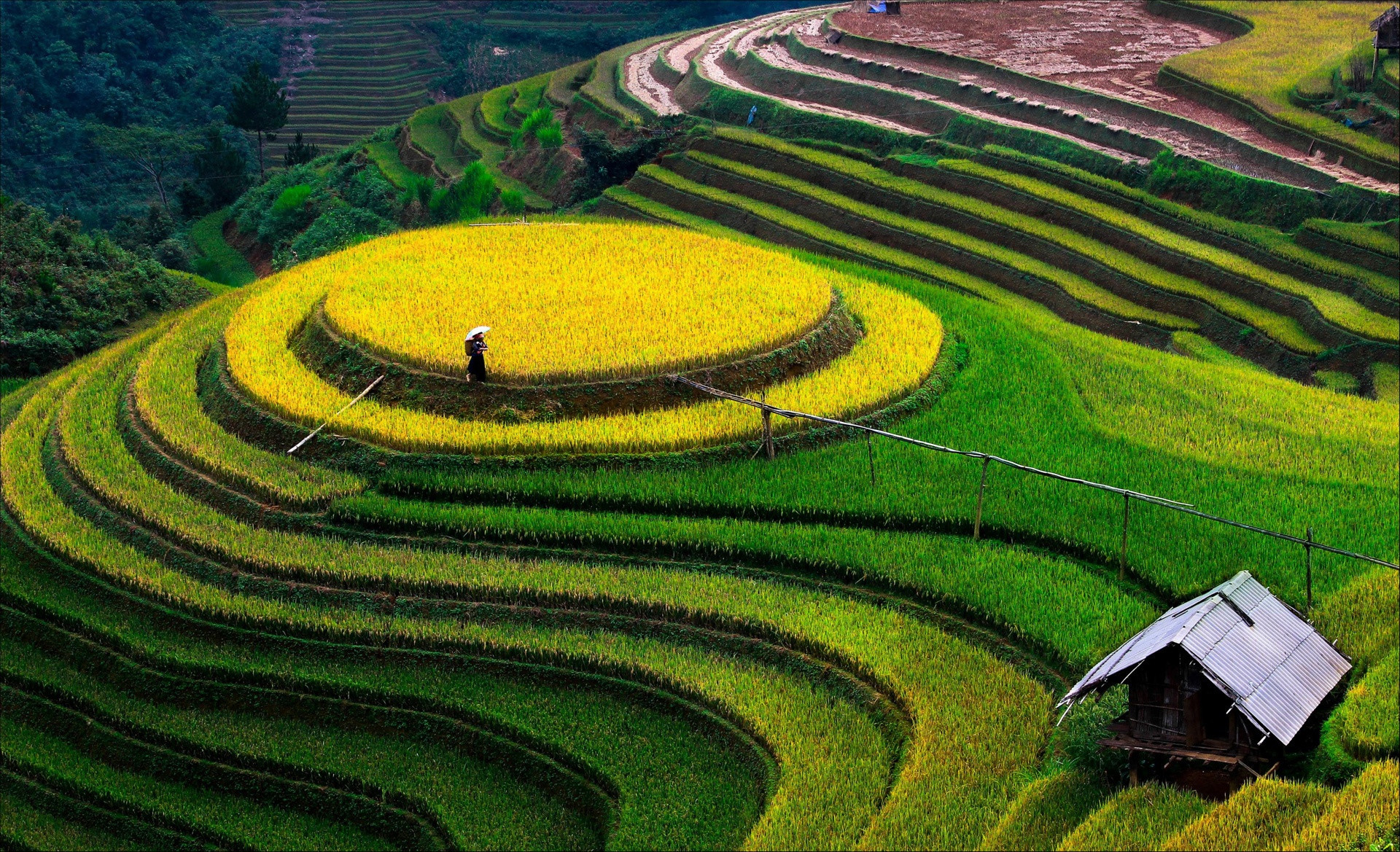
Mu Cang Chai terraced fields in September. Photo: Nguyen Anh Tuan - Dang Hong Long.

Ban Phung commune is about 30 km from the center of Hoang Su Phi district, Ha Giang province. It is home to La Chi ethnic people.

Lao Chai - Ta Van are two large villages of Sa Pa (Lao Cai), which are home to ethnic minorities such as Mong, Red Dao, and Giay. Photo: Thanh Tu.

World Travel Magazine voted Bac Son valley as one of the 10 most beautiful karst valleys in the world. Photo: Bui Thuan.
Na Lay peak is a great location to enjoy the panoramic view of Bac Son valley. Photo: Nguyen Anh Tuan.

Tu Le is a familiar destination for many backpackers on the way to discover Yen Bai. This is a valley located between three high mountains: Khau Song, Khau Than and Khau Pha. Photo: Nguyen Anh Tuan.

Lim Mong village is located on Highway 32, in Cao Pha commune, Mu Cang Chai district, Yen Bai province. Photo: Viet Manh.
Hoang Ha