 |
To restore the city’s identity successfully, it’s essential to recreate a model of its current geo-hydrology (rivers, canals and the Can Gio Sea) as the foundation for all urban zoning plans.
The harmony between nature and town is the essence of urban zoning, which respects the sacredness of the residence as the connection of the ecosystems for human growth. Therefore, all urban zoning theories at the beginning try to establish the internal balance between the man-made factor and the natural factor, starting with the treatment to the water ecosystems, including rivers, seas, lakes, lagoons, canals, flood lands and mangrove forests.
Long-term vision needed
In Vietnam, Saigon is the only city developed on land and water, or geo-morphology and geo-hydrology in technical terms. From its beginning some 300 years ago, Saigon was not a “riverside” city but a “waterway” city with a labyrinth of canals.
The zoning of the banks of the Saigon River and canals, which make up 16.8% of the city’s area, and the zoning of 110 hectares along the Nhieu Loc Canal in districts 1 and 3 to make HCMC a waterway city are creating the perspective of greeneries and canals intermingled with a small number of high-rise buildings. The zoning also embraces the connection of metro lines and elevated roads through the city center and the Saigon River to the Thu Thiem Peninsula.
These urban zoning plans probably mark the start of big renovations of all the 1,200-kilometer system of inner-city rivers and canals. The plans, still being drafted by the city authorities and just revealed through conferences and the media, may promise a turning point in the city’s in-depth cultural development after many years of excessive population and high-rise construction in the center. They may also be the remedy for the hasty omission of fundamental studies for the geo-hydrology system, which is being structurally destroyed through hot phases of development. This negative development, together with the impact of climate change when Can Gio Town will be developed at the mouth of the sea, will worsen the deadlock from urbanization of Saigon in the future.
A waterway city
With high mounds amidst rivers and canals, Saigon was the earliest agglomeration. Further, the position as the transport hub between the eastern and western regions and between Cambodia and the Central Highlands has made it favorable for its urban development.
The highest mound, explored first by the Vietnamese, was named Tan Khai whose peak is the area of the current television station. The mound covers the area from the Thi Nghe Canal to the Saigon River Estuary, which was named Tan Binh Giang under the Nguyen Lord, and Ben Nghe Canal, also called Tau Hu Canal when Cho Lon (Big Market) came into existence. Around the mound were countless ponds, canals, rivers and springs intermingled with forests, fields, mounds and hills. The Saigonese in the old time traveled mainly by boat through the Thi Nghe and Ben Nghe canals to reach the main river, creating the cultural identity of this free, open land.
Under the Nguyen Lord and the French rule, the two canals were dredged, enlarged and extended to facilitate waterway transport and urbanization at the end of the 19th century, turning Saigon into the “Pearl of the Far East” in Southeast Asia.
In the early 20th century, many canals connected with the Saigon River were filled to make thoroughfares and large boulevards, such as the Cho Vai Canal which was turned into Charner Boulevard and later Nguyen Hue Boulevard, and the Cau Sau Arroyo which became La Somme Boulevard and later Ham Nghi Boulevard. During 20 years from 1894 to 1914, the Boresse Marsh, a large area of ponds and swamps, were developed into the Ben Thanh Market and the central railway station. In 1928, the Binh Tay Market was built on the site of a shipyard in Hang Bang Canal, marking the southwestern expansion of Saigon. During several decades later, many ponds, lakes, canals and springs throughout Saigon-Cho Lon-Gia Dinh were filled to make the residence for war immigrants and the growing population during peace time.
Throughout four centuries, from the 17th to the 20th century, Saigon had grown from an unknown land to a waterway city and a port city leading in national and international trade. The first logo of the city had the words Paulatim Crescam, meaning that “Gradually I will grow.” And the city has gradually developed with its waterway nature, becoming a waterway city characterized by flood lands, mangrove forests, canals, lagoons, lakes, shipyards and ports with numerous activities on the water which formed its original culture.
Canals within the city
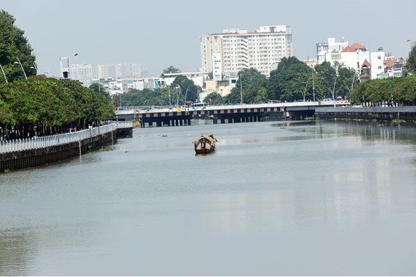
The two big canals for waterway transport, the Ben Nghe-Tau Hu (about 22 kilometers) and the Nhieu Loc-Thi Nghe (some 10 kilometers) which have been retained and renovated since the early 20th century, may become the hope for restoring the waterway identity of Saigon right in its historical center. They can be the historical sites, the waterway transport routes and the lung of the city.
The Ben Nghe-Tau Hu Canal, which is connected with the Cho Gao Canal in Tien Giang Province, was once the “rice route” for transport of paddy from the western region to rice mills in Cho Lon and then to Khanh Hoi Port for export worldwide. Under the French rule, a modern road with the first tramway between Saigon and Cho Lon was built along the canal.
During 1920-1930, the finance-banking quarter took shape in the area between Mong Bridge and Quay (formerly Trinh Minh The) Bridge, with the Bank of Indochina (now the State Bank of Vietnam, HCMC Office) as its typical landmark. The period also saw the development of the wholesale agro-product markets of Cau Ong Lanh and Cau Muoi, the Chinese quarter on Calmette and Pho Duc Chinh streets, the Indian quarter on Ton That Dam and Pasteur streets, and the old Cho Lon and new Cho Lon, which deserve as a heritage complex with many cultural, commercial and religious traits of the Chinese, Khmer and Vietnamese communities.
The Nhieu Loc-Thi Nghe Canal runs from District 1, with the Ba Son Shipyard (the shipyard of Lord Nguyen Anh in 1789) and the Zoological and Botanical Garden (the first in Indochina built in 1864)—the places where the French and Spanish armies landed in February 1859 to invade Saigon, to districts 3, Tan Binh and Phu Nhuan, which accommodated budget living quarters and makeshift houses as the mark of the population boom during the war.
The canal meanders with many bridges, temples, pagodas, churches and schools. Tan Son Nhat Airport came into existence in 1930 near the canal banks where many famous architectures and cultural heritages still exist, such as the Saint Paul Seminary, the History Museum, Ngoc Hoang Pagoda, Lang Ong Temple and Van Hanh University, which form part of the main cultural and historical sites of Saigon.
The area of Binh Dong Wharf-Vo Van Kiet Boulevard has warehouses and old condos which may become the sites for commercial buildings as expected by property developers. However, under the international practice, this large area should be the land for development of public and cultural works, recreation facilities and green space for walking when the city gets overburdened with population. This development may help the city solve many deadlocks about urban living quality. However, it’s not hopeful that the Nhieu Loc Canal renovation plan can give many benefits for the local residents; instead, it’s likely that the large area of 110 hectares may be filled with high-rise buildings of private developers, and so, the burdened infrastructure, traffic congestion and air pollution will get worse.
Revival and opportunity
With lots of efforts over the past 10 years, the two canals have been restored, expanded and cleaned to become two overland and waterway routes with greeneries and many public facilities on their banks. They still possess invaluable resources for urban development in the era of urban identity and urban greenery this century.
The Nhieu Loc-Thi Nghe Canal has the Saigon Locomotive Enterprise, called Chi Hoa Train Depot in the French time, a heritage seen as a “clean, golden” site by the canal side with a total area of nearly eight hectares housing three beautiful arched factories, a locomotive turntable and a railway linking Hoa Hung Railway Station. The entire complex can serve as a railway heritage for tourism along the canal. The two roads on both banks of the canal, the Hoang Sa and Truong Sa, are big waterway spaces which can recreate the history of a waterway city and connect the public activities with their huge greenery stretches. They should not be turned into heavily traffic routes with commercial buildings erected in the area of 110 hectares around. This is the way to destroy the scenic canal, which is the only opportunity for green urban development of Saigon, and is a shortsighted view over the future of the city.
Flood control
Many flood adaptation models have been proposed to prevent damage from flooding in urban areas. To make Saigon a flood adaptable city, it needs the development of a natural interactive structure between man and nature. Specifically, it’s the scenic stretch in the center of the Nhieu Loc-Thi Nghe Canal. The two big canals allow floods into the city as they are reservoirs to store floodwater which are used to nurture the urban ecosystem. Along with the water ecosystem and the water environment, the draft zoning should take into account risks from floods and strong tides, and have coping plans to raise the awareness and responsiveness of the community as well as to prepare for the entire water ecosystem of Saigon to adapt to flooding.
Conclusion
Before drafting the zoning, it’s essential to recreate a model of the current geo-hydrology system of Saigon (rivers, canals and the Can Gio Sea) as the foundation for all urban development plans. The more construction works is licensed, the more the natural flow of water is obstructed and the more flooding. In addition, it’s necessary to develop green infrastructure facilities imbued with Saigon’s waterway culture and history. In this regard, the focus should be put on the scenery, public facilities, promenade and connection of historical sites. High-rise building construction and dense population which destroy the opportunity of green urban development and a clean environment for Saigon should be avoided. SGT
(*) Institute for Settlement Research

River tides reach flood warning level 3 in HCM City, Mekong Delta
The Southern Regional Hydro-Meteorological Center has announced that river tides in HCM City and the Mekong Delta region reached flood warning level 3 on Monday and Tuesday.

Causes of dense smog in HCM City identified
Environmental monitoring devices at 30 spots in HCMC revealed that the volume of air pollutants have surged sharply, creating the heavy smog hanging over the city in recent days.