Vietnam's National Center for Hydro-Meteorological Forecasting has released its monthly climate outlook for the period from November 11 to December 10, 2025.
According to the forecast, 1–2 tropical storms or tropical depressions are likely to form in the East Sea during this time and may impact mainland Vietnam.
Historically, the East Sea experiences an average of 1.2 storms during this period, with 0.4 making landfall in Vietnam.
Current models suggest widespread heavy rain may occur across the southern part of Quang Tri Province, Da Nang, eastern Quang Ngai, Dak Lak, and Khanh Hoa.
In the Central Highlands and southern regions, scattered thunderstorms and showers are expected, especially concentrated in November.
Rainfall totals for areas from southern Quang Tri to Lam Dong may exceed the seasonal average by 30–60%.
Other regions may also experience above-average rainfall - by 10–30% - except for northern provinces and the stretch from Thanh Hoa to northern Quang Tri, where rainfall could be 10–30% below average.
The next month is also expected to see an increase in both frequency and intensity of cold air surges.
Consequently, average temperatures in northeastern Vietnam, the stretch from Thanh Hoa to Da Nang, and the eastern part of Quang Ngai are forecast to be 0.5–1°C lower than usual.
In other areas, average temperatures may also be slightly lower, by around 0.5°C.
Meteorologists warn that climate change is causing increasingly unpredictable and extreme weather patterns, including short but intense rainfall, flash floods, and landslides.
Authorities and residents are advised to regularly monitor short-term weather updates (1–3 days) for timely and appropriate responses.
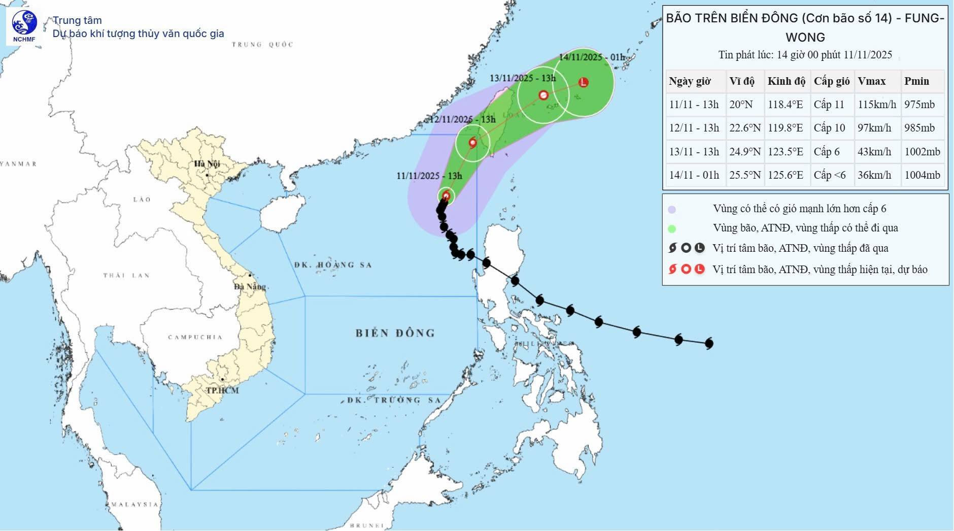
Regarding Tropical Storm Fung-Wong (Storm No. 14), as of 2:00 p.m. on November 11, the storm remained nearly stationary, moving slowly northward at 5–10 km/h.
The storm is forecast to exit the East Sea within the next 24 hours.
However, vessels operating in the northeastern part of the East Sea are advised to remain vigilant, as winds near the storm’s center may reach levels 9–11, with gusts up to level 14.
Waves in affected areas could rise between 4–6 meters, and even up to 9 meters near the storm center.
The sea will remain extremely rough.
Bao Anh