Forecasters expect the system to strengthen into a tropical storm between the night of July 2 and July 3, becoming Vietnam's first named storm of the year.
Based on current forecasts, there is about a 70% chance that the storm will move into the Gulf of Tonkin and directly affect the northeastern coastal provinces on July 4.
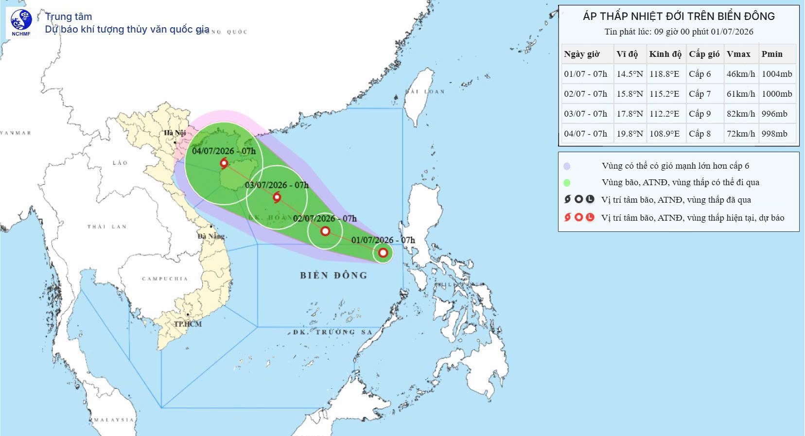
Over the next 24 hours, the tropical depression is expected to move west-northwest at 15-20 kph. By 7 a.m. on July 2, its center is forecast to be over the southern waters of the northern East Sea, with sustained winds of Beaufort Force 7 and gusts up to Force 8, while continuing to strengthen.
During the following 24 hours, the system is expected to move northwest at 15-20 kph and could intensify into a tropical storm with sustained winds of Force 8-9 and gusts up to Force 12. By 7 a.m. on July 3, the center is forecast to be over waters north of the Hoang Sa (Paracel) Islands.
Between 48 and 72 hours, the storm is expected to continue moving northwest at 15-20 kph.
Rough seas expected across multiple maritime areas
As the tropical depression strengthens, strong winds and rough seas are forecast across large parts of the East Sea.
The eastern waters of the northern and central East Sea, including the Hoang Sa Islands, are expected to experience Force 6 winds increasing to Force 7, with gusts reaching Force 10. Waves are forecast at 2-3 meters, rising to 3-4 meters near the center of the system, with very rough sea conditions.
On July 1, scattered showers and thunderstorms are forecast over the Gulf of Tonkin, the southeastern waters of the northern East Sea, the central and southern East Sea, including the Truong Sa (Spratly) Islands, waters from Lam Dong to Ca Mau, waters from Ca Mau to An Giang, and the Gulf of Thailand.
Thunderstorms may bring waterspouts, wind gusts of Force 7-8 and waves exceeding 2 meters.
On July 2, the northern East Sea, including the Hoang Sa Islands, is forecast to experience Force 6-7 winds with gusts of Force 8-9. Sea conditions are expected to become very rough, with waves reaching 3-5 meters.
The central East Sea is expected to see Force 6 winds, occasionally increasing to Force 7, with gusts of Force 8-9 and waves of 2-4 meters.
Southwesterly winds of Force 6, with gusts up to Force 7-8, are forecast for waters from Khanh Hoa to Ca Mau and the western waters of the southern East Sea, including the western waters of the Truong Sa Islands. Waves are expected to reach 2-3 meters.
The weather agency warned that vessels operating in these hazardous waters could face thunderstorms, waterspouts, strong winds and high waves.
Heavy rain likely across northern Vietnam
The combined weather systems are expected to bring a widespread spell of moderate to heavy rain across northern Vietnam from July 4 to July 7.
The rainfall could increase the risk of severe weather, including thunderstorms, lightning, flash floods, landslides and localized flooding, particularly in mountainous areas and low-lying locations.
Residents in northern Vietnam and Thanh Hoa Province are advised to closely monitor official weather forecasts and prepare for possible heavy rainfall during this period.
Bao Anh