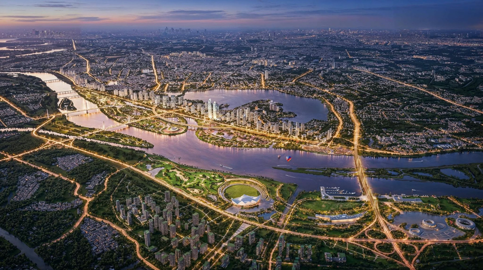
The Hanoi People’s Committee has officially approved the comprehensive adjustment task for the Red River subdivision zoning plan, with a scale of 1/5,000. The area covered stretches from Hong Ha Bridge to Me So Bridge, encompassing approximately 11,000 hectares.
By 2045, the zone is expected to accommodate up to 350,000 residents.
The project spans multiple wards and communes, including Thuong Cat, Dong Ngac, Phu Thuong, Tay Ho, Hong Ha, Bo De, Long Bien, Linh Nam, as well as O Dien, Me Linh, Thien Loc, Vinh Thanh, Dong Anh, Bat Trang, Thanh Tri, Nam Phu, and Hong Van.
According to the approved directive, the planning scope runs approximately 40 kilometers along the Red River, covering both inner-city and peripheral districts across the northern and southern belts of Hanoi.
The total area under planning adjustment is about 11,000 hectares, while the total study area for flood prevention purposes spans 11,425 hectares.
The boundaries largely follow the previously approved Red River zoning plans, with an expansion southward toward the proposed Me So Bridge. This aligns with the updated general planning for Hanoi through 2045, with a vision to 2065.
Projected population and purpose-driven density
Preliminary estimates forecast a population of 300,000 to 350,000 people living in the planning zone by 2045.
Of this, around 300,000 are aligned with the 2022-approved zoning plan. An additional 50,000 residents are expected to be incorporated to support urban reconstruction, resettlement, and relocation needs. Notably, this figure excludes the Long Bien–Cu Khoi riverside area, which falls under the E4 zoning subdivision.
Population and labor capacity are to be defined based on the area’s residential land carrying capacity, urban redevelopment goals, and compliance with national infrastructure and service standards.
Final population figures will be refined during the drafting of the detailed adjusted zoning plan.
A bold overhaul of existing urban fabric
The new vision proposes the transformation of both riverbanks into a continuous green corridor, lined with parks, waterways, cultural and recreational spaces. These are intended to become iconic venues for Hanoi’s festivals, tourism, and public life.
Special floodplain zones will be created, tailored to the river's natural landscape and aligned with disaster mitigation functions.
Importantly, the plan reaffirms that there will be no elevation of current dike systems, no construction of new dikes, and no encroachment on the existing floodplain. The city commits to maintaining approved flood safety standards, with elevation levels carefully calibrated to preserve natural drainage.
A key component of the revised zoning task is the strong restructuring of existing residential patterns, paired with selective upgrades in stable areas. Specific zones will be designated for "resettlement urban areas" to ensure adequate housing and land for residents affected by redevelopment.
The planning team will also identify suitable zones for new urban development on both sides of the river, with synchronized infrastructure, services, and a forward-looking urban vision that emphasizes modernity and quality of life.
Clear parameters for construction and relocation
The revised zoning plan must align with floodplain requirements. It will clearly define permissible construction zones, including the scale of additional development on designated 5% and 15% land reserves, resettlement zones, existing settlements to be preserved, new residential areas, and areas to be scaled up or down post-rezoning.
Further, the plan will identify areas designated for redevelopment, relocation, heritage village preservation, and the adaptive reuse of traditional craft villages. The restructuring process will focus on standardizing social infrastructure and forming modern residential clusters to elevate urban living standards.
Integrated infrastructure and riverbank connectivity
Transportation is another major focus of the adjustment plan, which calls for an integrated network of longitudinal and transverse roads along the Red River. This includes riverside scenic routes, new bridges, inland and tourist ports, and potential metro lines.
All transport systems must be coordinated with the city's urban design, landscape integration, and flood safety requirements, especially within the historic core of Hanoi.
Hong Khanh