 Vietnamnet.vn

 Podcast



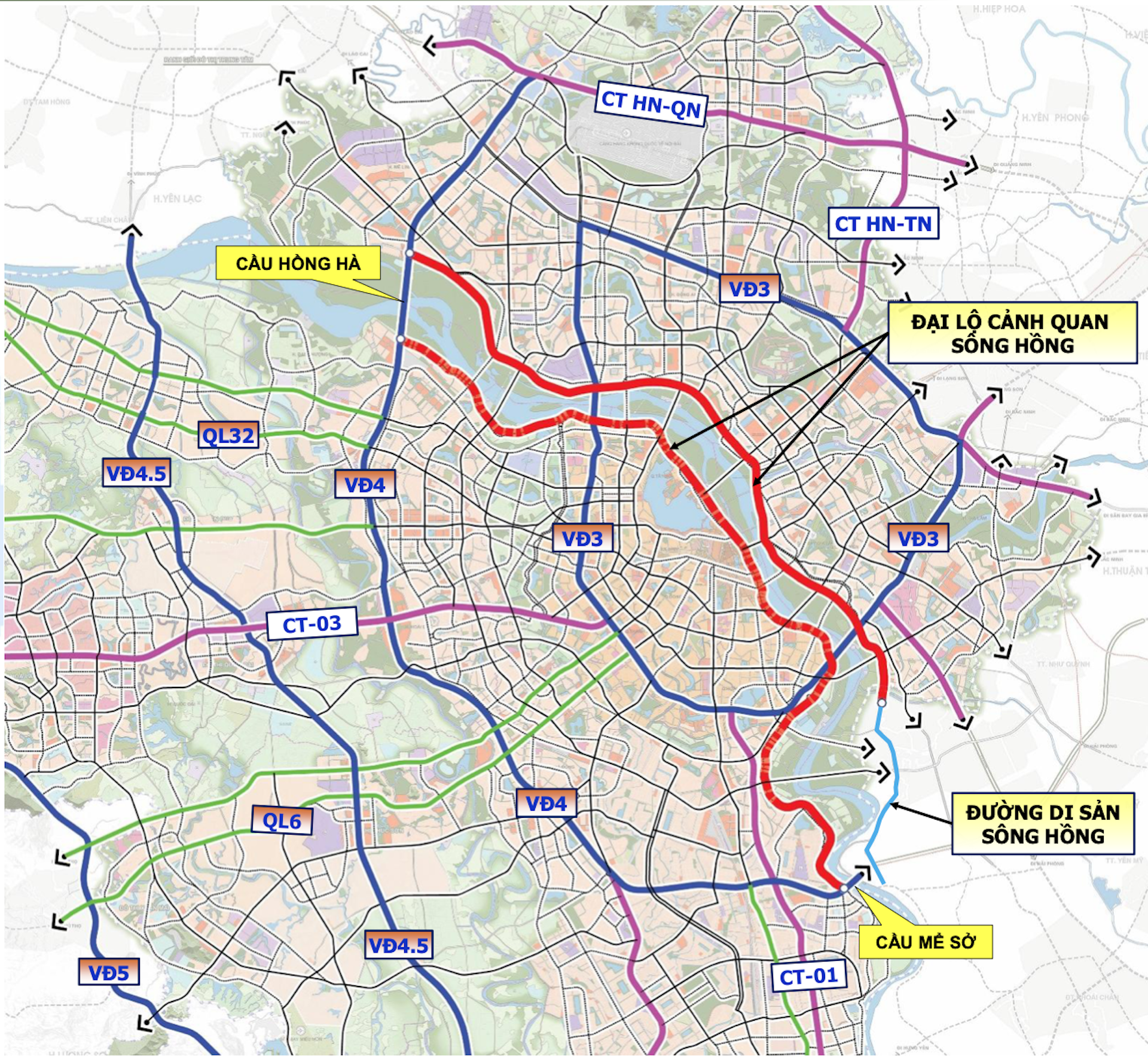
One of the most notable features is a proposed 2.3km enclosed tunnel running from the approach to Long Bien Bridge to beyond Chuong Duong Bridge.
The tunnel will accommodate six motor-vehicle lanes, with the total roadbed inside it measuring 55.5 metres wide.
According to the project consultant, the clearance between the natural ground level and the underside of the Long Bien and Chuong Duong bridge structures is only about 2.5-3.5 metres. A tunnel was therefore proposed to allow the boulevard to pass through the area.
Although the left-bank boulevard will pass beneath the Long Bien and Chuong Duong bridges, it will not connect directly to either. Both bridges will cross over the boulevard without an interchange.
The same arrangement is planned for Thang Long Bridge, which will cross the boulevard without a direct connection.
By contrast, at Nhat Tan, Vinh Tuy and Thanh Tri bridges, Hanoi plans grade-separated modified cloverleaf interchanges with both left- and right-turn ramps, similar to the Co Linh interchange between the Hanoi-Hai Phong Expressway and Ring Road 3.
For bridges currently under construction, the interchange on the left bank at Hong Ha Bridge is proposed as a modified cloverleaf, while Thuong Cat Bridge will have a full cloverleaf interchange.
Under the approved design for Tu Lien Bridge, the first phase includes a reserved connection point at pier P42 for the planned road. When the Red River Landscape Boulevard is built, interchange ramps will be completed and connected to this point.
At Tran Hung Dao Bridge, the boulevard will connect to roads on both sides of the bridge through entrance and exit ramps. The proposal also calls for moving the reserved connection point on the bridge about 130 metres toward central Hanoi.
For bridges that remain at the planning stage, their precise locations and river-crossing designs have yet to be determined, so no boulevard interchanges have been included. Connections will be studied when individual bridge projects are developed.
Boulevard to reach 73.5 metres at its widest
The boulevard’s cross-section will vary depending on location.
Where it runs close to the Red River’s left-bank dike, the main road will have six motor-vehicle lanes, with a two-lane frontage road on the right and the existing dike road serving as the frontage road on the left.
The roadbed will be about 54 metres wide, including a nine-metre pavement on the right for pedestrians and technical infrastructure.
Where the boulevard runs farther from the dike, the main carriageway will have six motor-vehicle lanes and the two frontage roads a combined four lanes. Nine-metre pavements on either side will bring the total roadbed width to as much as 73.5 metres.
Between Bac Cau Bridge and Thang Long Bridge, the cross-section will narrow to 49.5 metres, with six motor-vehicle lanes, two mixed-traffic lanes and three-metre pavements on each side.
The narrower design is intended to minimise impacts on Nui Temple, Rung Temple and Mau Thoai Phuc Xa Temple.
Along the section overlapping the Bat Trang dike, the roadbed will be 44.5 metres wide. The plan will use the existing Bat Trang dike road and frontage road as parallel roads alongside the boulevard’s six main motor-vehicle lanes.
At the Duong River crossing, Hanoi proposes building a bridge about 60 metres wide for traffic in both directions. Each direction will include a main carriageway, frontage road and pedestrian pavement.
The design principle is to avoid defence and security land as well as religious sites wherever possible. Where this cannot be avoided, approval from the relevant authorities will be required.
The plans also call for a review of underground and above-ground infrastructure, including electricity, telecommunications and fibre-optic systems, to ensure they can continue operating normally or be relocated in accordance with planning requirements.
Where the boulevard crosses irrigation and drainage canals, replacement, relocation or restoration measures will be required to maintain drainage and local agricultural production.
According to the published documents, the route and road boundaries may still be reviewed and fine-tuned during preparation of the feasibility study. Detailed cross-section specifications will also be finalised during the project development stage and submitted to the relevant authorities for approval.
17 bridges to cross the Red River boulevard
The plans identify different connections between the boulevard and bridges across the Red River.
On the left-bank route, direct connections are planned with Hong Ha, Lien Trung, Thuong Cat, Nhat Tan, Tu Lien, Tran Hung Dao, Vinh Tuy and Thanh Tri bridges. On the right-bank route, direct connections are planned with Hong Ha, Thuong Cat, Nhat Tan, Tu Lien, Chuong Duong, Thanh Tri and Ngoc Hoi bridges.
Existing bridges without direct connections will include Thang Long, Long Bien and Chuong Duong on the left-bank route, and Thang Long, Long Bien, Vinh Tuy and Me So on the right-bank route.
The planned Lien Trung, Tam Xa, Cu Khoi, Bat Trang and Khuyen Luong crossings have yet to have their precise locations or forms — bridge or tunnel — determined. As these crossings are not part of the priority ring-road corridors, they will not initially have direct interchanges with the boulevard. Connections will be studied when the individual crossings are developed.
Hanoi is also collecting public feedback on an overall adjustment to the Red River urban zoning plan between Hong Ha and Me So bridges, at a scale of 1:5,000, as well as the boulevard alignment.
Hanoi People’s Committee Chairman Vu Dai Thang inspected the public consultation process at the Hong Ha ward military command headquarters on September 12.
He encouraged residents to study the plans and focus their feedback on issues directly affecting their homes, livelihoods and living conditions.
Thang said the redevelopment of the Red River area is intended to create a new urban space and generate resources and momentum for Hanoi’s development. As the plans will affect many households, the city is developing an implementation roadmap with particular attention to land acquisition, relocation and resettlement.
“The city’s position is to seek public feedback on the Red River plan as we work toward transforming the river into a new space and creating resources for the city’s future development,” he said.
Resettlement areas to be completed first
Compensation, land clearance, resettlement locations and living conditions at new homes are among residents’ main concerns.
Thang said resettlement could not simply mean providing replacement housing. The city must also ensure access to social services, schools, workplaces and other essential infrastructure so residents can rebuild stable lives.
Plans should clearly identify where residents from individual areas will be relocated, which locations are suitable and what mechanisms will apply when the project is implemented.
The city will study arrangements for existing residential communities, particularly where people have lived for long periods but there is limited or no land available for on-site resettlement.
According to Thang, Hanoi has planned modern, multipurpose areas to support development along both banks of the Red River. These areas, particularly resettlement sites, must be developed comprehensively before residents are relocated.
During the consultation, residents called on the city to publish a detailed implementation plan and timeline so affected households can prepare.
Thang said the timetable was among the issues that needed to be incorporated into a clear roadmap. A key principle, he said, was that resettlement areas must be completed and provide adequate living conditions before residents are moved.
The city cannot allow people to leave their homes before resettlement areas have the infrastructure and services they need, he said. Schools, essential infrastructure and other facilities must be in place before relocation proceeds.
Thang also called for a transparent public consultation process that gives residents access to information and an opportunity to comment on matters directly affecting them.
The goal of redeveloping the Red River area is not only to reshape Hanoi’s urban landscape but also to create new space for development and improve residents’ quality of life.
“How can we work together to build an increasingly civilised, green, clean and beautiful city, and turn the Red River into a new space for development?” Thang said.
Hanoi will continue gathering feedback on the project timetable, resettlement locations, policies and infrastructure before refining the planning proposal and implementation roadmap, with the aim of balancing urban development with residents’ living conditions.
Thanh Hue
.svg)
