According to the National Center for Hydro-Meteorological Forecasting (NCHMF), average temperatures nationwide in July are expected to be 0.5–1 degree Celsius above the long-term average. Total rainfall is forecast to remain close to seasonal norms overall, although northern Vietnam and the area from Thanh Hoa to Ha Tinh are expected to receive 15–30% more rainfall than average.
Forecasters say tropical storm and tropical depression activity over the East Sea is likely to remain close to the long-term average. July typically sees around 1.6 tropical storms or tropical depressions over the East Sea, with approximately 0.9 systems expected to directly affect or make landfall in Vietnam.
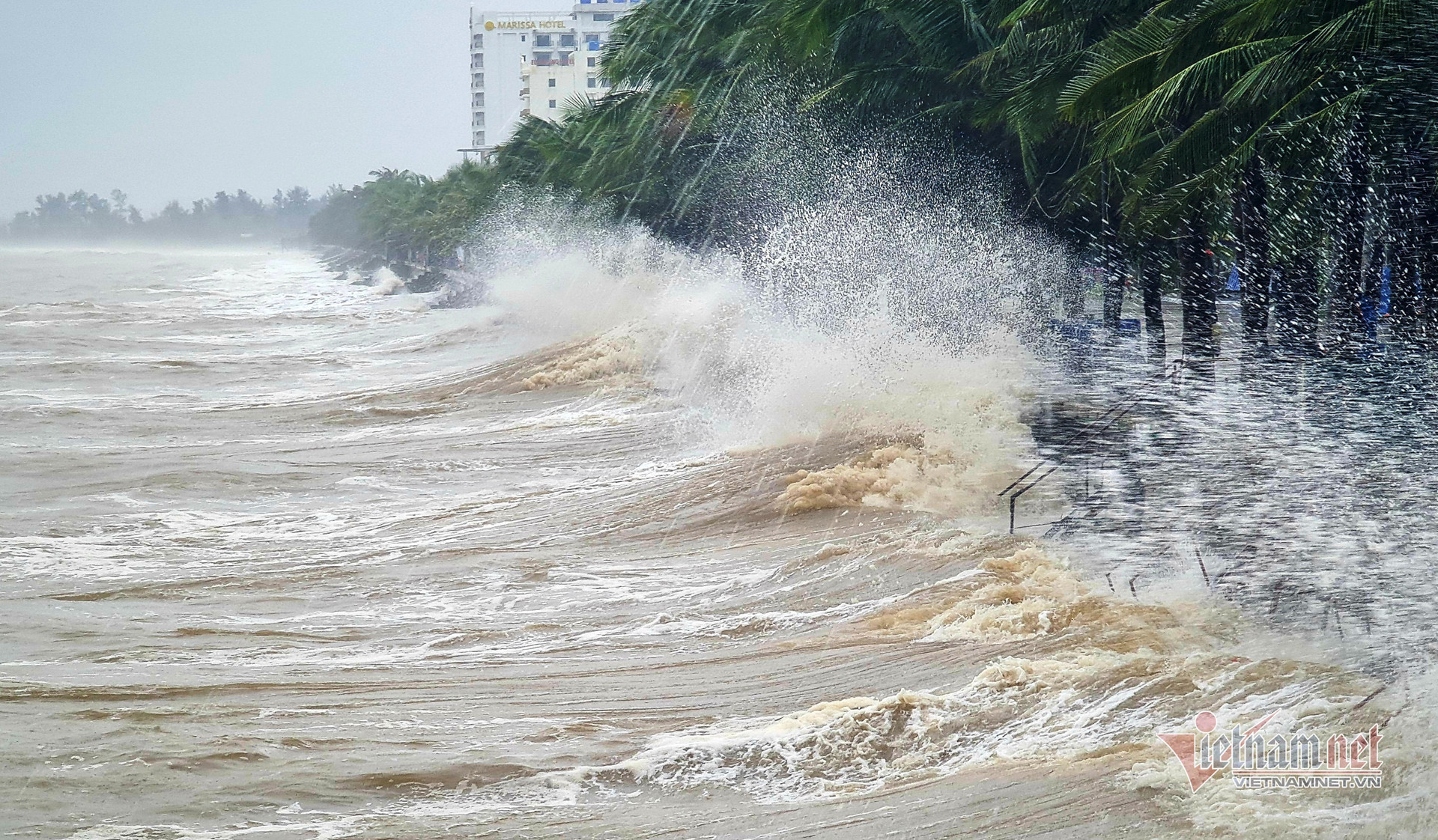
The forecast comes as the tropical depression over the East Sea continues to strengthen rapidly and is expected to become Storm No. 1 on July 2.
Meteorologists estimate there is currently about a 70% probability that the storm will move into the Gulf of Tonkin and directly affect the northeastern coastal region of northern Vietnam on July 4.
Heatwaves to persist as heavy rainfall increases
The weather agency also expects northern and central Vietnam to continue experiencing numerous hot days throughout July, with more heatwave days than the long-term average.
Some locations may experience severe and, in isolated areas, exceptionally severe heat, potentially affecting daily life, public health and production activities.
Meanwhile, widespread moderate to heavy rainfall is forecast mainly across northern Vietnam and the area from Thanh Hoa to Ha Tinh.
In the Central Highlands and southern Vietnam, showers and thunderstorms are expected on many days, with moderate to heavy rainfall in some locations, particularly during the afternoon and evening.
Forecasters also warn that thunderstorms, whirlwinds, lightning, hail and strong wind gusts could occur across most parts of the country, with higher risks in northern Vietnam, the Thanh Hoa–Ha Tinh region, the Central Highlands and southern Vietnam.
Northern Vietnam may experience widespread heavy rain
Over the next 10 days, from the night of July 1 to July 11, weather conditions across Vietnam are expected to remain unsettled, especially as Storm No. 1 is likely to form over the East Sea.
If the storm develops and follows the current forecast track, northern Vietnam could experience a widespread heavy rainfall event between July 4 and July 7.
Central and southern Vietnam are also forecast to receive scattered thunderstorms, with some areas likely to record very heavy rainfall. Thunderstorms may be accompanied by whirlwinds, lightning, hail and strong gusts.
Ten-day land weather outlook (July 1–11)
From the night of July 1 to July 3
Northern Vietnam: Scattered showers and thunderstorms are expected, with locally heavy rain. Mountainous and midland areas are forecast to receive moderate to heavy rain and thunderstorms on the evening and night of July 1, with isolated areas experiencing very heavy rainfall.
From Thanh Hoa to Hue and the south-central coast: Sunny conditions are expected during the day, with hot weather in some places. Scattered showers and thunderstorms are forecast during the evening and night, with locally heavy rain.
Central Highlands and southern Vietnam: Scattered showers and thunderstorms are expected, especially during the afternoon and evening. From July 2 onward, moderate rain and scattered thunderstorms are forecast, with isolated areas likely to receive heavy to very heavy rainfall.
Outlook from the night of July 3 to July 11
Northern Vietnam: Scattered rain and thunderstorms are expected, mainly during the night and morning. Between July 4 and July 7, widespread heavy rainfall is likely.
From Thanh Hoa to Hue and the south-central coast: Scattered showers and thunderstorms are forecast from July 3 to July 4, with locally heavy rainfall.
Central Highlands and southern Vietnam: Moderate rain and scattered thunderstorms are expected during the afternoon and evening through around July 4–5, followed by scattered showers and thunderstorms, with isolated moderate to heavy rainfall.
The weather agency warned that, amid increasingly complex climate change impacts, local authorities and residents should closely monitor one- to three-day weather forecasts and warnings to prepare appropriate response measures and ensure public safety and production activities.
According to Vietnam's National Center for Hydro-Meteorological Forecasting, at 7 a.m. on July 2, the center of the tropical depression was located near 17.1 degrees north latitude and 113.7 degrees east longitude in the northern East Sea, about 240 kilometers east-northeast of the Hoang Sa (Paracel) Islands.
Maximum sustained winds near the center reached Force 7 on the Beaufort scale (50-61 km/h), with gusts up to Force 9. The system was moving west-northwest at around 25 km/h.
Over the next 24 hours, the tropical depression is forecast to continue moving west-northwest at 10-15 km/h while strengthening into Storm No. 1, the first named storm to form over the East Sea during Vietnam's 2026 storm season.
By 7 a.m. on July 3, the storm's center is forecast to be over waters southeast of Hainan Island, China, with sustained winds of Force 8-9 and gusts reaching Force 11-12.
During the following 24 hours, the storm is expected to continue moving northwest at 10-15 km/h. By 7 a.m. on July 4, its center is forecast to enter the northern Gulf of Tonkin with sustained winds of Force 8 and gusts up to Force 10.
Between 48 and 72 hours, the storm is forecast to turn north-northwest, move at around 15 km/h and gradually weaken.
As the tropical depression strengthens into Storm No. 1, the northern East Sea, including the Hoang Sa Islands, is expected to experience Force 6-7 winds with gusts up to Force 9. Waves are forecast to reach 2-3 meters, producing rough seas.
From the afternoon of July 2, areas near the storm's center are expected to see winds strengthening to Force 8 before increasing to Force 9, with gusts of Force 11-12. Wave heights are forecast at 3-5 meters, with very rough seas.
Meteorologists warned that vessels operating in the affected waters face a high risk from thunderstorms, waterspouts, strong winds and large waves.
Bao Anh