Forecasts indicate that by tomorrow afternoon (July 22), Typhoon No. 2 (international name as Prapiroon) will enter the Gulf of Tonkin. The storm is expected to have an intensity of level 8 with gusts reaching level 10. The northern region will experience heavy rain from tomorrow night until July 24.
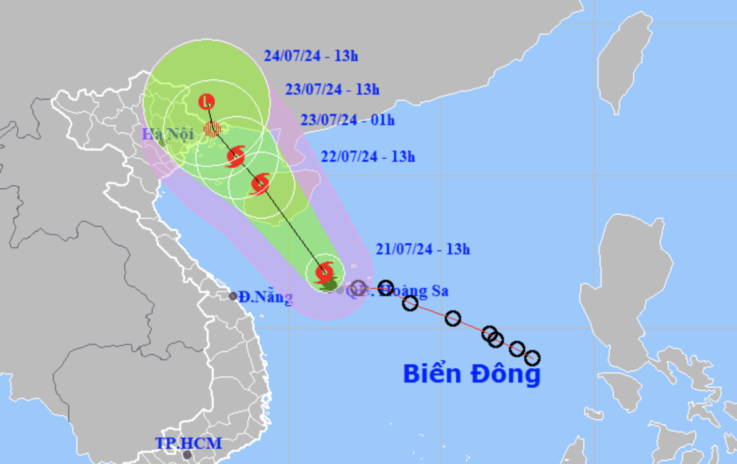
As of 4pm on July 21, Typhoon No. 2 was situated over the waters northwest of the Hoang Sa (Paracel) Islands, approximately 180 km southeast of Hainan Island (China). The strongest winds near the typhoon’s center were at level 8 (62 - 74 km/h), with gusts reaching level 10.
In the next 24 hours, the typhoon is expected to move northwest, maintaining its intensity, and make landfall on Hainan Island before entering the Gulf of Tonkin.
By 4pm, July 22, the typhoon’s center will be over the eastern part of the Gulf of Tonkin, maintaining its intensity with gusts up to level 10. In the following 24-48 hours, the typhoon is likely to weaken into a tropical depression before making landfall in the northeastern provinces on July 23.
The western waters of the northern East Sea, including the Hoang Sa Archipelago, the eastern waters from Quang Tri to Quang Ngai, and the eastern part of the southern Gulf of Tonkin will experience strong winds of level 6-7 and rough seas.
From the morning of July 22, the northern Gulf of Tonkin, including Bach Long Vi and Co To islands, will face increasing winds up to level 6-7, with winds near the typhoon's center reaching level 8 and gusts up to level 10, accompanied by very rough seas.
On land, from early on July 23, Quang Ninh Province's coastal areas may experience strong winds of level 6, with gusts up to level 8.
From July 21 night until July 24, moderate to heavy rain and thunderstorms are expected in the North and Thanh Hoa province, with some areas experiencing very heavy rain. Coastal areas in the North and northeastern regions may receive 100-200 mm of rain, with some exceeding 250 mm. Other areas in the North and Thanh Hoa could receive 50-100 mm of rain, with some exceeding 150 mm.
There is a high risk of localized flooding in small rivers and streams, inundation in low-lying and urban areas, and landslides in mountainous regions and steep slopes.
Response measures
The Prime Minister has directed ministries, agencies, and coastal provinces from Binh Dinh to Quang Ninh, as well as northern mountainous provinces, to proactively respond to Typhoon No. 2 and associated heavy rain.
Specifically, the Prime Minister requires:
- Safety Measures for Boats: Guide boats, vessels, and tourist ships still operating at sea or along the coast to move to safe shelters or out of dangerous areas. Proactively evacuate residents from hazardous areas, especially those at risk of landslides and flash floods.
- Emergency Response: Deploy forces to monitor, control, and ensure traffic safety through flooded areas and landslide-prone zones. Prohibit passage for people and vehicles where safety cannot be guaranteed.
- Infrastructure Protection: Implement measures to protect reservoirs, dams, and dikes. Minimize damage to aquaculture, agriculture, industry, and infrastructure.
- Ministry of Agriculture and Rural Development and Ministry of Industry and Trade: Coordinate with localities to manage irrigation and hydropower reservoirs safely, prevent artificial floods, and reduce downstream flooding. Notify the public before flood discharge operations and ensure safety for aquaculture, agriculture, industry, and electrical systems.
- Ministry of National Defense and Ministry of Public Security: Direct relevant units to assist with evacuations, rescue operations, and aftermath response in coordination with local authorities.
This directive emphasizes the importance of proactive measures to ensure safety and minimize damage from the impending typhoon.
PV