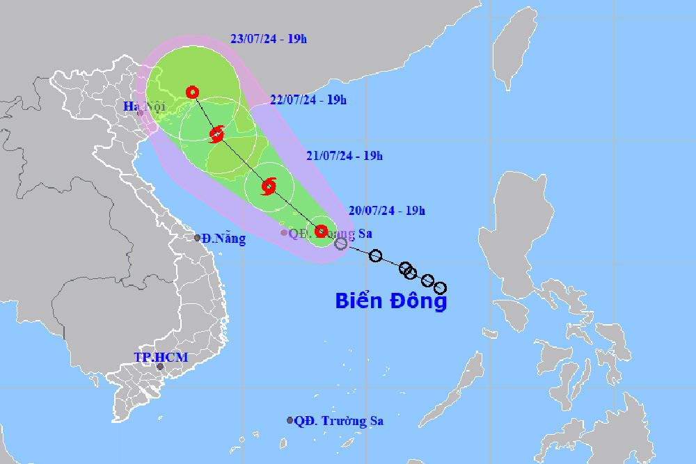
The depression, currently marked by winds at level 7 (50-61 km/h) and gusts up to level 9, poses significant risks of heavy rainfall and strong winds.
As of the evening of July 20, the system was located about 180 km east of the Hoang Sa Archipelago, moving northwest at a pace of 10-15 km/h. Forecasters anticipate it will evolve into a typhoon by July 21, positioning its center near the southeastern waters of Hainan Island, China, with sustained winds reaching level 8 and gusts at level 10.
The typhoon is expected to approach the northern Gulf of Tonkin by July 22, sustaining strong winds and high gusts, and gradually weakening after July 24. Nonetheless, it will continue to influence weather conditions significantly in the northern and central regions of the East Sea, including the Hoang Sa Archipelago.
The Ministry of Agriculture and Rural Development has issued directives to coastal provinces from Quang Ninh to Binh Thuan to brace for the storm. Additionally, the Department of Dyke Management and Natural Disaster Prevention is ensuring that fishermen and maritime vessels are secured and guided to safety, mitigating the risks associated with the turbulent weather.
The National Center for Hydro-Meteorological Forecasting has outlined the potential impacts across various regions from July 20 to 26:
- Northern Vietnam: Scattered thunderstorms with potential heavy rains, especially at night and early morning.
- Central Vietnam: Intermittent showers and thunderstorms, with occasional heavy rainfall during the evening and night.
- Central Highlands and Southern Vietnam: Consistent moderate to heavy rain, intensifying during the afternoon and night.
- Hanoi: Expected thunderstorms accompanied by moderate to heavy rainfall, primarily in the afternoon and evening.
Authorities urge caution, particularly in mountainous and midland areas prone to flash floods and landslides. The general public is advised to stay updated with weather forecasts and adhere to safety guidelines issued by local authorities.
Bao Anh