The remnants of storm Bualoi continued to cause heavy rain and flooding across many provinces in northern and north-central Vietnam. With its unusual speed, intensity, and prolonged impact, the storm left behind severe human and material damage.
Tornado caught on camera in Ninh Binh.
On the evening of September 29, meteorologists from the National Center for Hydro-Meteorological Forecasting (NCHMF) offered their preliminary assessment of storm Bualoi, calling it an exceptionally severe and unusual event that caused widespread destruction.
On the night of September 26, Bualoi entered the eastern sea area of the central East Sea, becoming the tenth named storm of 2025, with sustained winds of level 12 and gusts reaching level 15. It moved northwestward at an unusually fast pace of 35 km/h.
After entering the East Sea, the storm maintained its intensity and trajectory, slowing slightly to 30-35 km/h on the afternoon of September 27. By the morning of September 28, its speed further reduced to around 25 km/h.
Late on September 28, Bualoi made landfall between Ha Tinh and northern Quang Tri with winds reduced to level 11 and gusts to level 14, continuing northwest at 20-25 km/h. By the morning of September 29, it moved into the border area between Nghe An and central Laos, further weakening to level 8 with gusts at level 10. By noon, it became a tropical depression and then a low-pressure system over upper Laos.
Unusual characteristics of storm Bualoi

Mai Van Khiem, Director of the NCHMF, described Bualoi as one of the most intense storms in recent history, notable for several rare features. One was its high speed: averaging 30-35 km/h, nearly double the pace of typical storms.
Another was its unusually long presence over land. From around 10 p.m. on September 28 until 10 a.m. on September 29, Bualoi remained a powerful storm for over 12 hours - a rarity for this region, which contributed to its destructive force.
The storm’s circulation brought heavy rains across northern Vietnam and from Thanh Hoa to Hue, with some areas receiving more than 500mm of rainfall.
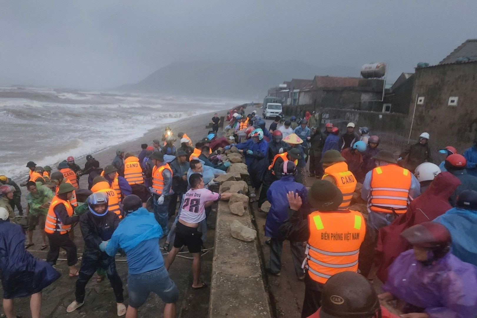
Strong winds of level 6 or higher impacted 11 of 21 coastal provinces, with areas from Ninh Binh to Quang Tri experiencing winds at level 8 and gusts up to level 14. The most affected zones, from southern Ha Tinh to northern Quang Tri, faced winds of level 10-11, with gusts up to 13-14.
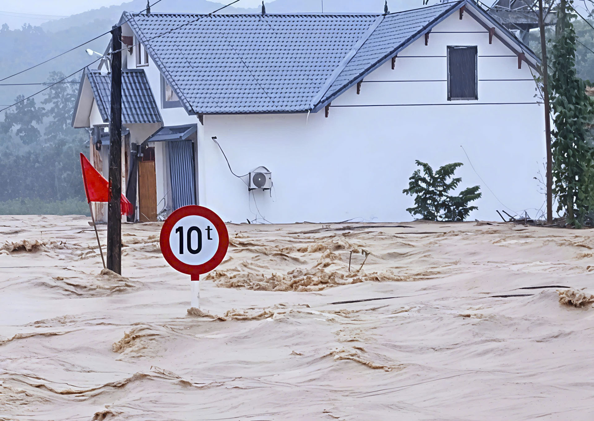
Torrential rain caused severe flooding on rivers, including the Kien Giang (Quang Tri), upper Chu and Ma (Thanh Hoa), Ca (Nghe An), and Ngan Pho (Ha Tinh), with levels exceeding alert level 3.
The risk of landslides, flash floods, and inundation was high across the northern provinces and from Thanh Hoa to Hue, especially in Thanh Hoa and Ha Tinh.
"This was one of the most severe and destructive natural disasters in recent memory," Khiem said. "Multiple extreme phenomena occurred almost simultaneously - violent storm winds, severe floods, flash floods, landslides, and widespread inundation - affecting infrastructure and daily life from coastal areas to lowlands, midlands, and mountainous regions."
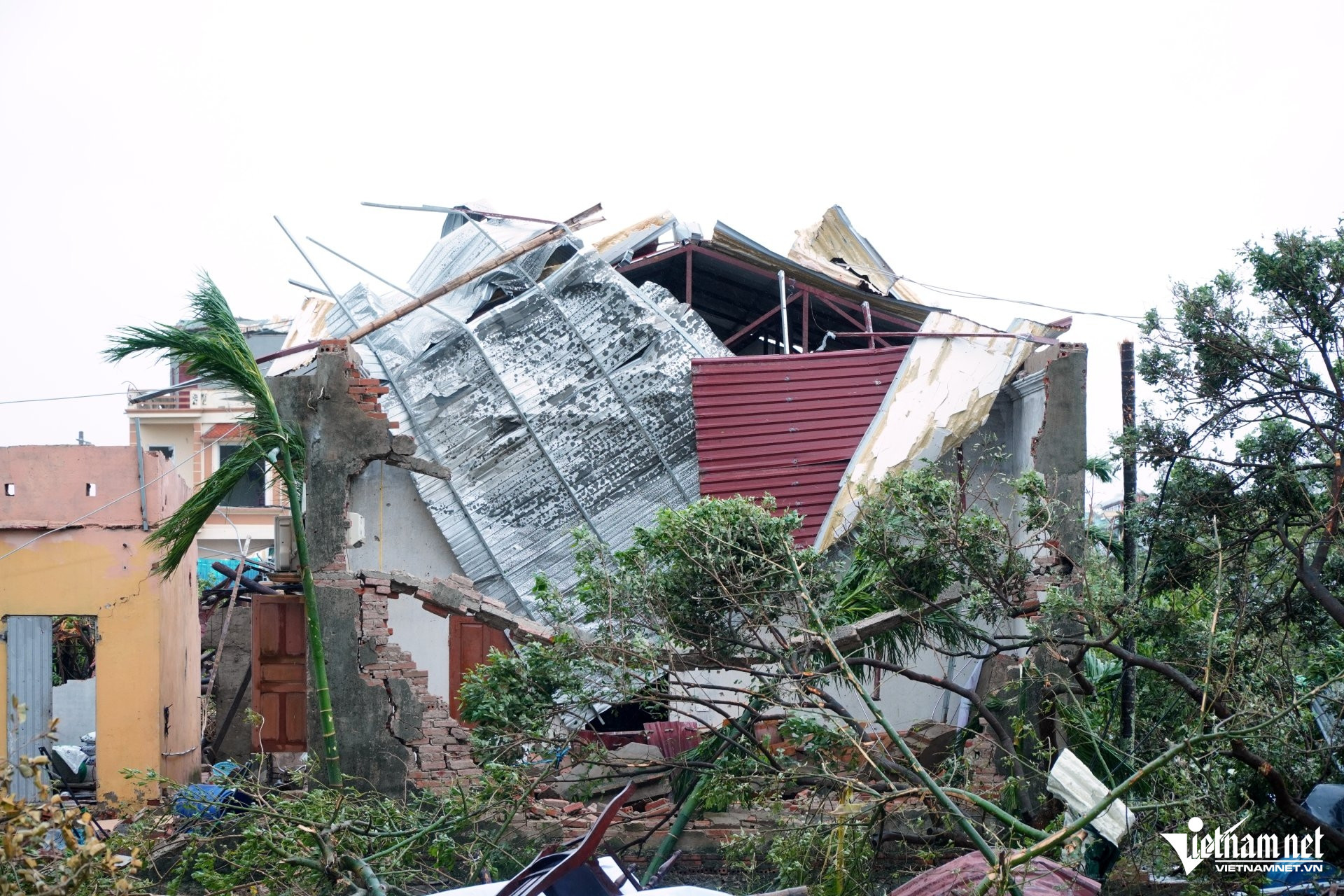
Eight tornadoes hit northern provinces
Dr. Nguyen Ngoc Huy, a climate change and disaster risk expert, stated that Bualoi broke three records. It was the fastest-moving storm ever recorded in the East Sea, at times reaching 40 km/h.
It also spent the longest time battering a single province. In Ha Tinh, the storm lingered for 11 hours.
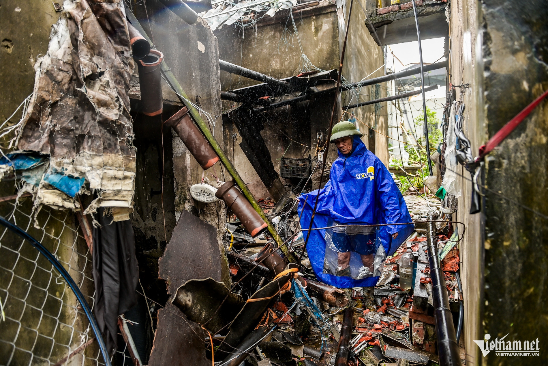
“In some areas, over half the houses lost their roofs. Others were reduced to rubble, leaving only foundations and broken walls. Recovery will take a long time,” Huy said.
He also noted that within a single day - September 29 - Bualoi triggered eight tornadoes across eight provinces: Nam Dinh, Ninh Binh, Hai Phong, Hai Duong, Thanh Hoa, Thai Binh, Quang Ninh, and Hanoi.
The tornado in Ninh Binh left nine people dead and 18 injured. Eleven single-story houses collapsed, 126 were damaged or lost roofs, and 53 utility poles fell.
Another deadly tornado struck Thai Thuy commune in Hung Yen, killing two. The storm swept away metal roofs and even toppled reinforced gates.
Tornadoes also caused heavy damage in Hai Phong, Quang Ninh, and other areas, destroying crops and properties.
Flooding hits multiple areas
Nguyen Ba Thuy, Deputy Director of the NCHMF, reported that storm Bualoi’s landfall between northern Quang Tri and Ha Tinh brought strong winds, high waves, and storm surges across the coast from Hue to Hai Phong.
Offshore wave heights were recorded at 6-8m near Ha Tinh and northern Quang Tri. Nearshore waves from Nghe An to Hai Phong ranged from 2-5m, with Hon Ngu station observing 4-5m waves.
The storm caused sea level rises of 0.5 to 1.6m, with Hon Ngu reaching 1.6m, Sam Son 1.1m, and Hon Dau 0.7m.
Though the storm’s landfall coincided with low tide, its storm surge extended into the morning of September 29 - just as high tide peaked - causing widespread flooding in low-lying and coastal areas, especially in Cua Lo (Nghe An) and Sam Son (Thanh Hoa).
Flooding is expected to subside by late September 30, but strong winds may continue to generate 2-3m waves until then.
From the evening of September 29 through September 30, heavy rain will continue in Son La, Phu Tho, and Lao Cai, with rainfall ranging from 70-150mm and localized totals above 250mm.
Other parts of northern Vietnam and Thanh Hoa will see 50-100mm, with some areas exceeding 200mm. Flash floods and landslides remain likely, particularly with rainfall exceeding 150mm within 3 hours.
Between 4:40 a.m. and 10:40 a.m. on September 30, there is heightened risk of landslides and subsidence on steep slopes and near streams in Son La, Phu Tho, Lao Cai, Tuyen Quang, Thai Nguyen, Cao Bang, Lang Son, Quang Ninh, Bac Ninh, Thanh Hoa, Nghe An, and Ha Tinh.
As of 3:00 p.m. on September 29, reports from Ninh Binh, Nghe An, Ha Tinh, Quang Tri, Hue, Da Nang, and Quang Ngai confirmed 13 deaths, 13 missing, and 8 unaccounted for. A total of 44,230 houses were damaged or had roofs blown off, 824 homes were flooded, and 5,979 hectares of rice and crops were submerged or destroyed.
Strong winds
According to weather stations: Co To (Quang Ninh) recorded level 7 winds with gusts at level 9; Bach Long Vi (Hai Phong) had level 8 winds and level 9 gusts; Hon Ngu (Nghe An) saw level 10 winds and gusts up to 14, with storm surges reaching 1.6m; Con Co (Quang Tri) had level 10 winds and gusts at level 11.
Coastal areas from Quang Ninh to northern Quang Tri experienced winds of level 6-9 and gusts of 10-12. Near the storm center, winds reached level 10-11 with gusts up to 14. At Dien Chau station (Nghe An), winds were level 11 with gusts at 13; Hoanh Son (Ha Tinh) recorded level 11 and gusts at 14; Ky Anh (Ha Tinh) had level 10 winds with gusts at 12.
Rainfall totals
From September 26 to 28, Hue to Da Nang received 200-450mm of rain, with some stations exceeding 500mm: Hong Trung (Hue) 627mm, Huong Nguyen (Hue) 619mm, Suoi Luong (Da Nang) 409mm.
From September 26 to 29, Ha Tinh to Quang Tri saw 200-400mm, with localized peaks: Cho Trang (Ha Tinh) 578mm, Son Hong 1 (Ha Tinh) 517mm, Huong Son (Quang Tri) 541mm, Ho Vuc Tron (Quang Tri) 523mm.
In the same period, Thanh Hoa to Nghe An recorded 300-500mm, with several areas over 550mm: Nong Truong 15 (Nghe An) 836mm, Yen Thuong (Nghe An) 672mm, Xuan Binh (Thanh Hoa) 739mm.
From September 28 to 29, the Red River Delta, Phu Tho, southern Son La, and Lao Cai saw 70-120mm. Southern Phu Tho and southern Son La experienced 100-250mm, with some areas exceeding 250mm: Van Mai (Hoa Binh) 404mm, Lung Van (Hoa Binh) 365mm, Muong Do 1 (Son La) 339mm.
Bao Anh