The storm is expected to weaken further into a low-pressure system by tomorrow.

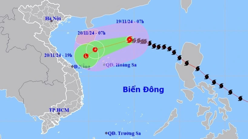
Storm No. 9 (Man-yi) has weakened to Level 9 with gusts at Level 11. As of 7 AM on November 19, the storm was located in the northern part of the East Sea, about 350km east-northeast of the Hoang Sa Archipelago, according to the National Center for Hydro-Meteorological Forecasting (NCHMF). The storm is moving westward at 15–20 km/h and is expected to continue weakening.
Path and forecast: By 7 AM on November 20, the storm's center will be west of the northern East Sea, about 190km northwest of the Hoang Sa Archipelago. Wind strength is expected to drop to Level 7 (50–61 km/h) with gusts at Level 9. In the next 12 hours, Storm No. 9 is projected to move toward the waters off Central Vietnam at 10 km/h, weakening into a tropical depression and eventually dissipating into a low-pressure system.
Impact areas: The northern East Sea, including the waters around Hoang Sa, will experience strong winds of Level 6–7, with areas near the storm’s center reaching Level 8–9 and gusts up to Level 11. Waves in the affected areas will rise 3–5m, reaching 5–7m near the storm’s core. The seas are expected to be extremely rough. Maritime activities in the affected zones will face severe disruptions due to strong winds and high waves.
In the past six hours, provinces from Thua Thien Hue to Binh Dinh have experienced moderate to heavy rainfall. Soil moisture models indicate saturation levels exceeding 85% in some areas, with several zones fully saturated. This poses a very high risk of flash floods and landslides.
Bao Anh