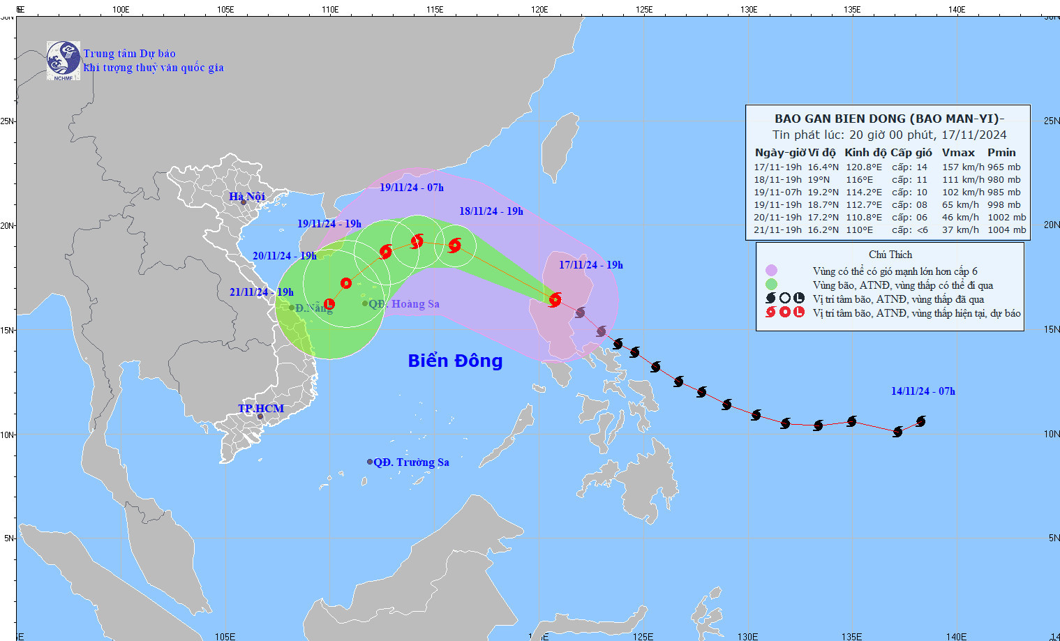
Typhoon Man-yi has made landfall in the eastern region of Luzon Island, Philippines, with its intensity no longer classified as a super typhoon after weakening by two levels. It is expected to enter the East Sea late tonight or early tomorrow morning (November 18), becoming Storm No. 9 of the 2024 storm season.

According to the National Center for Hydro-Meteorological Forecasting (NCHMF), as of 7:00 PM on November 17, Typhoon Man-yi was located inland on Luzon Island, Philippines. The storm's maximum wind speed near its center was level 14 (150-166 km/h), with gusts reaching level 17. The typhoon is moving northwest at a speed of approximately 25 km/h.
In the next 24 hours, the storm will continue moving northwest at 20-25 km/h, entering the East Sea and becoming Storm No. 9 of the 2024 rainy season.
By 7:00 PM on November 18, the storm's center is forecast to be over the northern East Sea, about 470 km northeast of the Hoang Sa Archipelago. At this point, its intensity is expected to weaken to level 11, with gusts at level 14.
Forecast for the next 24-96 hours:
- 24-72 hours: Man-yi will move south-southwest at a speed of 5-10 km/h and gradually weaken into a tropical depression.
- 72-96 hours: The tropical depression will further weaken into a low-pressure area.
Meteorologists predict that as Typhoon Man-yi enters the East Sea, it will likely interact with cold air currently spreading across Vietnam, causing the storm to weaken rapidly.
Despite its weakening, the storm is expected to cause severe conditions in the northern East Sea, including:
- Winds of level 8-10, increasing to level 11-13 near the storm's center, with gusts reaching level 15.
- Waves of 3-5 meters, rising to 5-7 meters near the storm's center.
- Hazardous thunderstorms, squalls, and rough seas.
Vessels operating in these areas are warned to expect dangerous weather conditions.
The meteorological agency noted that the cold air mass currently moving southward is expected to reach parts of the northeastern regions of North Vietnam tonight, spreading to other areas in North and North-Central Vietnam and parts of Central Vietnam by tomorrow.
- Inland areas will experience northeast winds at level 3, while coastal areas will face level 4 winds.
- From November 18, mornings and evenings in northeastern regions and Thanh Hoa will turn chilly. By November 20, the weather in North Vietnam and North-Central Vietnam will become cold in the mornings and evenings, with temperatures dropping to 18-20°C, and below 15°C in mountainous areas.
- In the Gulf of Tonkin: Starting November 18, northeast winds will strengthen to level 6, with gusts at level 7-8. The sea will become rough, with waves reaching 2-3.5 meters.
- In the northern East Sea (including the waters near the Hoang Sa Archipelago): Winds will reach level 6-7, with gusts at level 8-9, causing rough seas and waves of 2-4 meters.
Additionally, disturbances from high-altitude easterly winds combined with the cold air may bring rain and thunderstorms to parts of North and Central-Central Vietnam from the early morning of November 18 to 19, with localized areas experiencing heavy rain.
Bao Anh