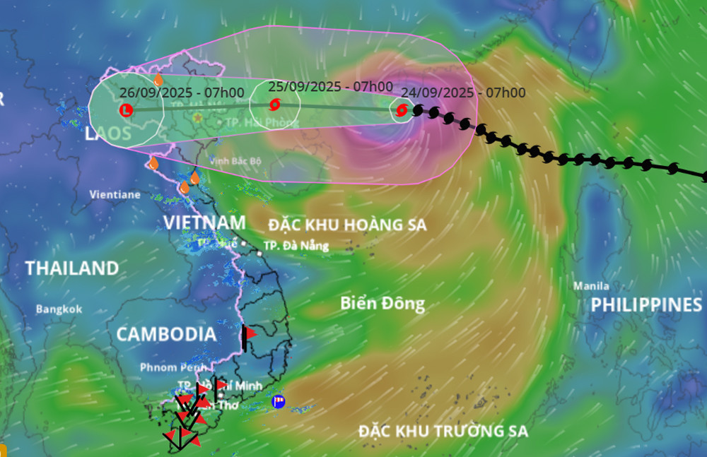
The National Center for Hydro-Meteorological Forecasting reported this morning (September 24) that after moving into the southern waters off Guangdong Province, China, Typhoon Ragasa had reduced in strength to level 15 (167–183 km/h), no longer qualifying as a super typhoon (level 16 or higher).
By 7 AM, the storm's eye was approximately 620 km east of Mong Cai (Quang Ninh), traveling west-northwest at about 20 km/h.
Over the next 24 hours, Ragasa is expected to continue moving west-northwest at 20-25 km/h, gradually weakening. By 7 AM on September 25, the storm’s center will be over the waters between Quang Ninh and Hai Phong, with winds reaching levels 10-11 and gusts up to level 13.
From noon to afternoon on the same day, the storm is likely to make landfall in Vietnam, with Quang Ninh and Hung Yen expected to be the primary impact zones. The storm will then move quickly westward at 25-30 km/h, weakening into a tropical depression as it crosses Hanoi and Phu Tho, and eventually downgrading into a low-pressure system over the northwestern region of northern Vietnam.
Severe thunderstorms and heavy rains expected in northern Vietnam
Due to the effects of Typhoon Ragasa, the northern part of the East Sea is experiencing winds of level 10-13, with areas near the storm's eye reaching levels 14-16 and gusts exceeding level 17. Waves in these areas exceed 10 meters in height, making for extremely rough seas.
Starting this afternoon, the eastern part of the northern Gulf of Tonkin, including Bach Long Vi, will see winds increasing to level 6-7 with gusts up to level 9. By tonight, the northern Gulf of Tonkin - including Bach Long Vi, Van Don, Co To, Cat Hai, and Hon Dau islands - will experience winds of level 8, waves of 2-4 meters, and areas near the storm's eye reaching levels 9-11 with gusts up to level 13 and waves of 3-5 meters, creating dangerously rough sea conditions.
Coastal areas in Quang Ninh may see storm surge-induced sea level rises of 0.4–0.6 meters, posing a high risk of dike and embankment erosion, aquaculture zone destruction, and damage to moored boats due to strong winds, high waves, and rising sea levels.
Of particular concern, starting early tomorrow (September 25), coastal areas from Quang Ninh to Ninh Binh will experience increasing winds of level 6-7, with areas near the storm's eye reaching levels 8-9 and gusts up to level 11. Inland areas in northeastern Vietnam will also see winds of level 5, with some areas reaching level 6 and gusts up to levels 7-8.
From tonight through the night of September 26, northern Vietnam, along with Thanh Hoa and Nghe An provinces, will experience heavy to very heavy rainfall, ranging from 100 to 250 mm, and locally over 400 mm. Urban flooding is possible due to high rainfall intensity. Flash floods and landslides may also occur in low-lying areas and along steep slopes.
Meteorologists warn that due to the storm’s wide circulation, there is a high risk of thunderstorms, tornadoes, and strong gusts both before and during landfall.
Additionally, the northwestern Pacific Ocean is now tracking the 20th typhoon of 2025, named Bualoi. This storm, named after a Thai dessert, is expected to enter the East Sea in about three days. The National Center for Hydro-Meteorological Forecasting plans to release its first official bulletin on Typhoon Bualoi on the morning of September 25.
Bao Anh