 Vietnamnet.vn

 Podcast



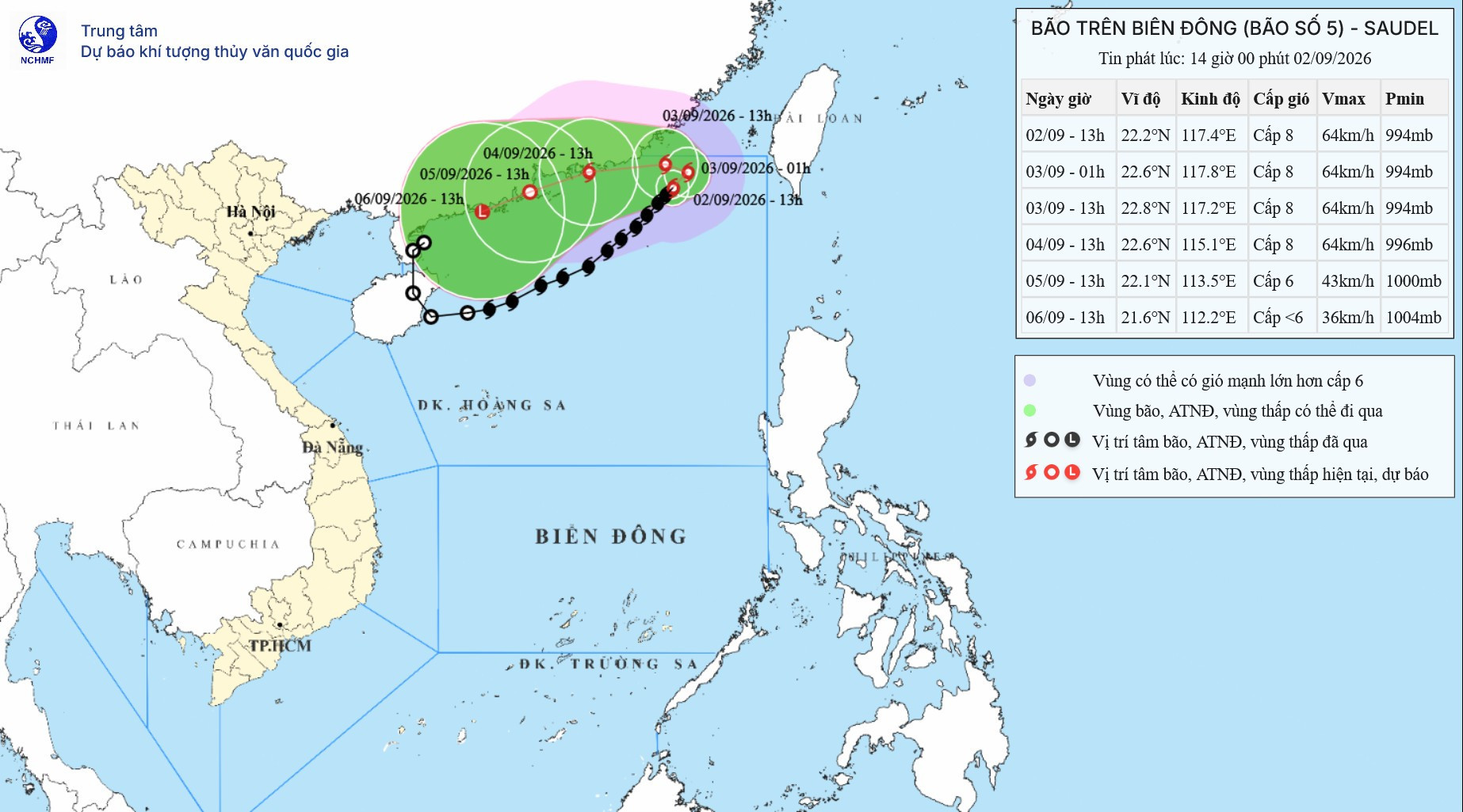
Storm Saudel, the fifth storm to enter the East Sea this year, has made an unusual change in direction after slowing significantly over the northeastern part of the sea.
According to Vietnam’s National Center for Hydro-Meteorological Forecasting, at 1 p.m. on September 2, the center of Saudel was over the northeastern waters of the northern East Sea.
Maximum sustained winds near the storm’s center were at Level 8, or 62-74kph, with gusts reaching Level 10. It was moving northeast at around 5-10kph.
Over the next 24 hours, Saudel is forecast to move north-northeast at about 5kph. By 1 p.m. on September 3, its center is expected to remain over the northeastern waters of the northern East Sea, maintaining Level 8 winds and Level 10 gusts.
The storm is then forecast to make a sharp turn west and accelerate to around 10kph. By 1 p.m. on September 4, its center is expected to reach coastal waters southeast of Guangdong Province in China, while maintaining Level 8 winds and Level 10 gusts.
Saudel will subsequently move west-southwest at 5-10kph. By 1 p.m. on September 5, it is expected to remain in coastal waters southeast of Guangdong and gradually weaken into a tropical depression, with winds falling to Level 6 and gusts reaching Level 8.
Over the following 72 to 96 hours, the tropical depression is forecast to continue moving west-southwest at 5-10kph before weakening further into a low-pressure area.
The latest forecast adds another twist to Saudel’s highly unusual journey.
The storm originally formed over the western Pacific between August 15 and 24 and intensified into a super typhoon.
From August 25 to 28, Saudel swept across southern Japan, bringing heavy rain and widespread power outages to Kagoshima before making landfall in China’s Zhejiang Province, where it caused heavy rainfall and severe flooding.
After moving deep inland over China, Saudel weakened into a low-pressure area. But instead of dissipating, the system moved south toward waters east of China’s Leizhou Peninsula, where it reorganized.
On the morning of August 31, the system strengthened again into a tropical depression before intensifying into a storm over the East Sea on September 1, becoming Vietnam’s fifth numbered storm of 2026.
According to experts, tropical cyclones can regenerate after crossing islands in the open ocean, but a storm reviving after making landfall and traveling over a large landmass is extremely rare.
Since re-forming, Saudel has continued to follow an erratic path.
Early on September 2, the storm was moving northeast at around 15kph. Forecasters expected it to slow rapidly, with its speed falling to just 5-10kph over the following days.
It was initially forecast to turn west-northwest and move slowly toward waters southeast of Guangdong before weakening into a tropical depression.
By the afternoon, however, the forecast track had shifted again. Saudel was expected to move north-northeast before turning sharply west, bringing it back toward the area where it had re-formed.
Despite its unusual movement, the storm is expected to remain primarily at sea and is not forecast to make landfall in Vietnam.
Strong winds and high waves across the East Sea
Saudel’s slow and changing course is expected to generate dangerous conditions across extensive areas of the East Sea.
The northeastern waters of the northern East Sea are forecast to experience winds of Levels 6-7, with gusts reaching Levels 8-9 and waves of 3-5 meters.
Near the storm’s center, winds could reach Level 8 with Level 10 gusts, while waves are forecast at 4-6 meters, producing very rough seas.
The southern part of the northern East Sea, including the waters around the Hoang Sa archipelago, and the central East Sea are forecast to experience westerly to southwesterly winds at Level 6, occasionally reaching Level 7, with Level 8 gusts. Waves are expected to reach 3-5 meters.
Waters from Khanh Hoa to Ho Chi Minh City and the northern part of the southern East Sea, including waters north of the Truong Sa archipelago, are forecast to see southwesterly winds at Level 6, with gusts of Levels 7-8 and waves of 2-4 meters.
Authorities warned that vessels operating in these dangerous areas could be affected by thunderstorms, tornadoes, strong winds and high waves.
Because Saudel is moving slowly, hazardous weather conditions at sea could persist for an extended period. Vessel operators have been advised to take precautions and closely monitor updated forecasts.
Bao Anh
.svg)
