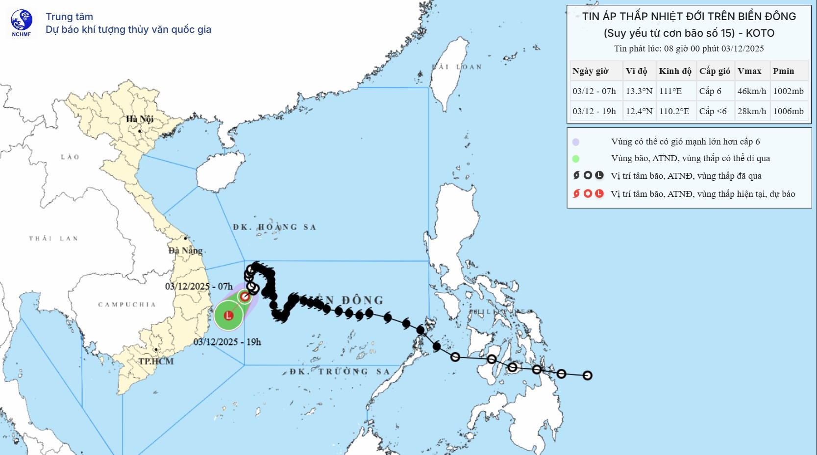
Within the next 12 hours, it is expected to maintain its direction, move at about 10 km/h, and weaken into a low-pressure system. By 7:00 PM the same day, the low-pressure center is projected to be offshore between the provinces of Dak Lak and Khanh Hoa.
Meanwhile, cold air has begun sweeping into the northeastern region, gradually spreading to north-central, northwest, and northern central coastal areas. Northeasterly winds will strengthen to levels 2–3, reaching levels 3–4 along the coast. Light to moderate rain is expected in the northern and north-central provinces.
From tonight, temperatures will drop sharply, with the highlands in the northern mountains experiencing cold to very cold weather. Forecasts predict lows of 15–18°C in the northern delta, 13–15°C in the mountains, and even below 12°C in some places. North-central provinces will see lows of 16–18°C.
In Hanoi, scattered showers are expected today (December 3). From tonight, the weather will turn cold, with temperatures dropping to 15–18°C.
Due to the combined influence of strengthening cold air, the remnant circulation of storm Koto, and upper-level disturbances in the easterly wind belt, moderate to heavy rains are expected from the night of December 2 through December 4 across central Vietnam.
Specifically, areas from southern Quang Tri to Da Nang, the eastern parts of Quang Ngai to Dak Lak, and Khanh Hoa will experience widespread rainfall.
Last night and this morning, showers and thunderstorms were recorded in Hue, the south-central coast, and the Central Highlands, with some areas seeing very heavy rain.
Rainfall from 7:00 PM on December 2 to 8:00 AM on December 3 exceeded 60 mm in several locations, including 70.6 mm at Tam Tra (Da Nang) and 81.4 mm at Dak Gan (Lam Dong).
Forecasts for today and tonight suggest rainfall of 40–100 mm in these areas, with localized totals exceeding 150 mm.
Tomorrow (December 4), areas from southern Quang Tri to Da Nang and eastern Quang Ngai may receive 40–80 mm of rain, with some places again topping 150 mm.
Warnings are in place for intense rainfall exceeding 100 mm within a 3-hour period.
Elsewhere, showers and thunderstorms are expected across the Central Highlands and southern Vietnam, with rainfall amounts ranging from 10–30 mm and isolated totals above 80 mm.
From December 5 onward, heavy rainfall in southern Quang Tri, Da Nang, and eastern Quang Ngai is expected to subside.
Meteorologists caution that, while major flooding is unlikely given current conditions, landslides remain a risk - especially in areas with cracked hillsides following the major flooding event in November.
There is also a heightened risk of urban flooding, flash floods in small rivers and streams, and landslides on steep slopes.
Due to the influence of the tropical depression, strong winds (level 6, gusts level 8) and waves of 2–4 meters are affecting the northwestern part of the central East Sea and offshore areas from Dak Lak to Khanh Hoa.
Additionally, due to strengthening cold air, northeasterly winds in the northern East Sea will increase to levels 6–7, gusting to levels 8–9, with waves reaching 3–5 meters and very rough seas.
In the Gulf of Tonkin, winds are expected to reach level 6, occasionally level 7, with gusts up to level 8. Waves will rise to 2–4 meters, creating dangerous sea conditions.
From the afternoon of December 3, seas from southern Quang Tri to Hue and the northern central East Sea will face northeast winds at level 6, gusting to levels 7–8, and waves of 3–5 meters.
Vessels operating in these hazardous zones may encounter thunderstorms, squalls, strong winds, and large waves.
Bao Anh