 Vietnamnet.vn

 Podcast


Champi becomes strongest storm in northwest Pacific in 2026
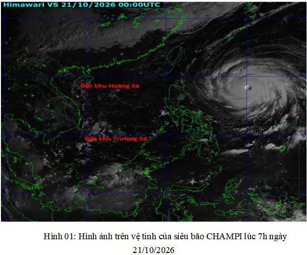
Vietnam's National Center for Hydro-Meteorological Forecasting reported that as of the morning of October 21, Super Typhoon Champi was located near 18.1 degrees north latitude and 130.2 degrees east longitude, approximately 800km east-southeast of Luzon Island in the Philippines.
The storm had reached force 17 on Vietnam's wind scale, with gusts exceeding force 17.
According to the latest satellite analysis, Champi's maximum sustained winds were estimated at around 210km/h, while its central atmospheric pressure had fallen to 900 hectopascals (hPa).
At this intensity, the storm is comparable to a Category 5 super typhoon under the classification used by US meteorological authorities.
Current analysis indicates that Champi is the strongest storm to develop in the northwest Pacific in 2026, surpassing the intensity of Super Typhoon Sinlaku.
Satellite imagery shows a highly organised and powerful storm system, with a well-defined, relatively symmetrical eye measuring approximately 80km across.
Champi could bring strong winds and high waves to northern East Sea
Analysis of large-scale atmospheric steering patterns at pressure levels of 500-700hPa shows that Champi is currently positioned southwest of a subtropical high-pressure system.
The typhoon is moving over waters with sea surface temperatures of approximately 29-30°C, conditions that favour the maintenance of its extreme intensity.
Over the next 24 hours, Champi is expected to remain at force 17, with gusts exceeding force 17, while moving mainly west-northwest at around 20-25km/h.
From October 22, the storm is forecast to gradually turn northwest.
As it moves farther north into areas with lower sea surface temperatures, its intensity is expected to weaken progressively.
According to Vietnam's National Center for Hydro-Meteorological Forecasting, the latest projections from meteorological agencies in Japan, South Korea, China and the United States have become more consistent regarding Champi's expected track compared with forecasts issued over the previous two days.
The current outlook suggests that the typhoon is unlikely to make a direct landfall in Taiwan (China).
By around October 24, when Champi reaches waters east of Taiwan, it is forecast to weaken to force 10, with gusts reaching force 13.
The storm could then turn northeast, heading toward Japan and South Korea.
By October 25, as it approaches waters south of Japan and South Korea, Champi is expected to weaken further to force 8, with gusts reaching force 10.
Based on the latest forecast, Super Typhoon Champi is not expected to enter the East Sea.
Nevertheless, given its force 16-17 intensity and extensive circulation, the storm's western outer bands could generate winds of force 6-7, with gusts of force 8-9, over the northeastern waters of the northern East Sea.
Wave heights in the affected area could reach 2-4 metres, creating hazardous conditions for vessels operating offshore.
Vietnam's National Center for Hydro-Meteorological Forecasting is continuing to closely monitor the development and movement of Super Typhoon Champi.
Bao Anh

