 Vietnamnet.vn

 Podcast



Super Typhoon Dolphin is continuing to strengthen over the northwestern Pacific as it tracks toward China's eastern coast, while northern Vietnam is preparing for another month of heavy rainfall and heightened flood risks.
Although the storm is not expected to enter the East Sea, its circulation is forecast to strengthen the southwest monsoon and create hazardous marine conditions from early August.
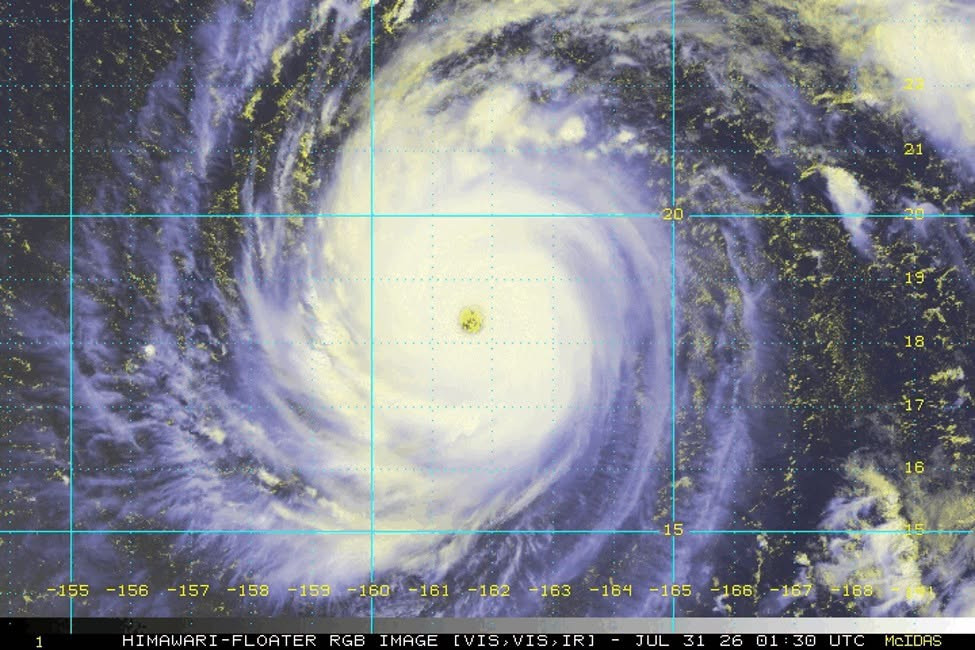
According to Vietnam's National Center for Hydro-Meteorological Forecasting (NCHMF), as of 8:30 a.m. on July 31, the center of Super Typhoon Dolphin was located at 18.3°N and 161.9°E, more than 4,200 kilometers east of Luzon Island in the Philippines.
The storm has intensified to the upper end of Category 17 on Vietnam's wind scale, with gusts exceeding Category 17, making it the fourth super typhoon to form over the northwestern Pacific in 2026 after Sinlaku, Bavi, and Mekkhala.
Forecasters expect Dolphin to continue moving west-northwest at around 20 km/h over the next one to two days while gaining additional strength. Sustained winds near the eye could reach about 115 knots, potentially matching the intensity of Super Typhoon Sinlaku.
From August 3, the storm is forecast to shift onto a more westerly track, accelerate to around 25 km/h, and head toward the coastal provinces of Fujian and Zhejiang in eastern China.
Although current forecast models show no indication that Dolphin will enter the East Sea, meteorologists say the storm's immense circulation is likely to affect regional weather as it approaches northern Taiwan (China).
Beginning around August 5, the southwest monsoon is expected to strengthen across the southern East Sea. Between August 6 and 7, southwesterly winds could reach Force 6-7 across much of the northern, central, and southern East Sea, including the Hoang Sa (Paracel) and Truong Sa (Spratly) special zones.
Wave heights are forecast to range from 2 to 4 meters, with rough to very rough seas posing risks to fishing vessels and other maritime activities.
The NCHMF said it is closely monitoring the storm and will continue issuing updated forecasts and warnings as Dolphin evolves.
Northern Vietnam faces another wet month
While the powerful storm remains far offshore, northern Vietnam is expected to endure another month of above-average rainfall.
Nguyen Duc Hoa, Deputy Head of the Climate Forecast Division at the NCHMF, told VietNamNet that total rainfall across northern Vietnam in August is forecast to be 10-25% higher than the long-term average.
Despite the increased rainfall totals, the number of rainy days is expected to remain relatively low, with precipitation falling in shorter but significantly more intense episodes.
Between April and July 2026, cumulative rainfall across northern Vietnam was generally close to seasonal averages. However, rainfall during July exceeded normal levels by 20-40% in the northwestern and mountainous provinces, while northeastern areas recorded totals 10-20% below average.
Meteorological data also show that the region experienced only about 60 rainy days during the April-July period, compared with a long-term average of 68 days and 70 days during the same period last year. The trend suggests rainfall is becoming increasingly concentrated in shorter, more intense events.
According to Hoa, persistent heavy rain throughout July was driven primarily by a stationary low-pressure trough over northern Vietnam. Embedded upper-level circulations between 3,000 and 5,000 meters, combined with strong southeasterly winds carrying abundant moisture, created favorable conditions for repeated thunderstorms, particularly across the northern midlands and mountainous provinces.
Saturated soils raise landslide concerns
Authorities warned that repeated heavy rainfall has left soils across much of northern Vietnam's mountainous regions at or near saturation.
As a result, even moderate rainfall over a short period could trigger flash floods, landslides, and flooding in low-lying urban areas throughout August.
Officials say disaster risks remain particularly high in mountainous districts where the ground has already absorbed significant amounts of water over recent weeks.
El Niño strengthens but does not rule out heavy rain
The weather agency also reported that El Niño continues to intensify and is expected to remain strong to very strong through early 2027.
However, forecasters stressed that a strengthening El Niño does not necessarily mean northern Vietnam will experience less rainfall.
As a large-scale climate pattern, El Niño affects different regions unevenly and usually influences local weather with a delay of two to three months.
Historical records show no consistent relationship between El Niño and rainfall in northern Vietnam. During some El Niño years, rainfall has exceeded long-term averages, while in others it has fallen well below normal.
Meteorologists therefore say heavy rainfall events remain entirely possible despite the developing El Niño conditions.
Warmer weather expected through the end of the year
Looking ahead, the NCHMF forecasts fewer tropical storms and tropical depressions over the East Sea than the long-term average through the remainder of 2026.
At the same time, temperatures nationwide are expected to remain 0.5-1.5 degrees Celsius above normal, with some locations recording anomalies of up to 2 degrees Celsius.
Heatwaves are likely to continue affecting northern and central Vietnam through August and early September before gradually easing.
The winter of 2026-2027 is forecast to arrive later than usual and be warmer overall, although brief outbreaks of severe cold are still possible.
Rainfall in northern Vietnam is expected to remain near or above average through the end of the year, while central Vietnam may experience below-average rainfall during its peak rainy season in October and November.
Meanwhile, the rainy season is forecast to end earlier than usual in central Vietnam, the Central Highlands, and southern Vietnam, increasing the risk of drought, saltwater intrusion, and water shortages during the opening months of 2027.
Bao Anh
.svg)
