 Vietnamnet.vn

 Podcast



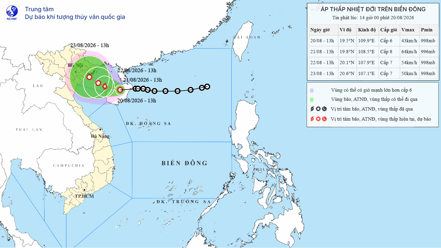
A tropical depression near Hainan Island is forecast to enter the Gulf of Tonkin and could intensify into the fourth storm to form over the East Sea this year, according to Vietnam’s National Center for Hydro-Meteorological Forecasting.
At 1pm on August 20, the center of the tropical depression was over the northern part of Hainan Island, China.
Maximum sustained winds near its center were at 39-49kph, with gusts reaching a higher level.
The system was moving west at a relatively slow speed of 5-10kph.
Over the next 24 hours, the tropical depression is forecast to shift west-northwest at 5-10kph, enter the Gulf of Tonkin and potentially strengthen into a storm.
By 1pm on August 21, the storm’s center is expected to be over the eastern waters of the Gulf of Tonkin, with sustained winds of 62-74kph and gusts of up to 89-102kph.
If the system develops into a storm as forecast, it will become Storm No. 4 in the East Sea in 2026.
A Level 3 disaster risk warning has been issued for waters in the northwestern part of the northern East Sea and the Gulf of Tonkin.
Storm expected to move slowly after entering Gulf of Tonkin
During the following 24 hours, the system is forecast to turn west and move even more slowly, at just 3-5kph, while gradually weakening.
By 1pm on August 22, its center is expected to be over the northern Gulf of Tonkin, with sustained winds of 50-61kph and gusts of up to 75-88kph.
A Level 3 disaster risk warning will remain in effect for the Gulf of Tonkin.
Over the following 48-72 hours, the tropical depression is forecast to continue moving west at around 3-5kph, with sustained winds of 39-61kph and stronger gusts.
The system’s slow movement means hazardous marine conditions could persist across affected waters.
In the northwestern waters of the northern East Sea, winds are forecast at 39-49kph with stronger gusts. Waves could reach 2-4 meters, leaving the sea rough.
From the evening of August 20, conditions in the Gulf of Tonkin are expected to deteriorate, with winds strengthening to 39-61kph.
Near the storm’s center, winds could reach 62-74kph, with gusts of up to 89-102kph. Waves are forecast to rise to 2.5-3.5 meters, producing very rough seas.
Authorities warned that vessels operating in the affected areas could face thunderstorms, waterspouts, strong winds and high waves.
Bao Anh
.svg)
