Typhoon Kalmaegi is expected to enter the East Sea on the morning of November 5. Starting from the night of November 6, it may directly impact the central coastal provinces from Da Nang to Khanh Hoa, with winds reaching 74-93 mph (Category 1-2 hurricane equivalent), and gusts possibly exceeding 107-115 mph.
According to the Hydrometeorological Department under the Ministry of Agriculture and Environment, Kalmaegi will become the 13th typhoon to enter Vietnamese waters in 2025.
Latest forecast models confirm Kalmaegi as a fast-moving and extremely powerful storm. It is projected to reach intensity levels equivalent to Category 3 hurricanes (above Level 13-14) near the Spratly Islands and offshore areas between Da Nang and Khanh Hoa.
"Starting from the night of November 6, Typhoon Kalmaegi is likely to directly affect the area from Da Nang to Khanh Hoa. Coastal regions, including Ly Son Island, could experience sustained winds of 75-93 mph (Level 12-13), with gusts surpassing 107 mph (Level 15+). Mainland areas along the central coast may be hit with winds reaching 62-74 mph, and gusts up to 107-115 mph," meteorological experts stated.
They also warned of possible thunderstorms and tornadoes preceding the typhoon’s landfall. Widespread rainfall is expected from November 6 to 9 across areas from Quang Tri to Dak Lak, raising the threat of new floods along rivers from Quang Tri to Khanh Hoa.
Authorities emphasize that current observational data and forecasts still carry uncertainty in Kalmaegi’s trajectory, intensity, and direction. Rainfall zones and amounts may fluctuate in the coming days. All ministries, agencies, local authorities, and residents are urged to closely follow official bulletins to prepare accordingly.
Kalmaegi continues accelerating and intensifying
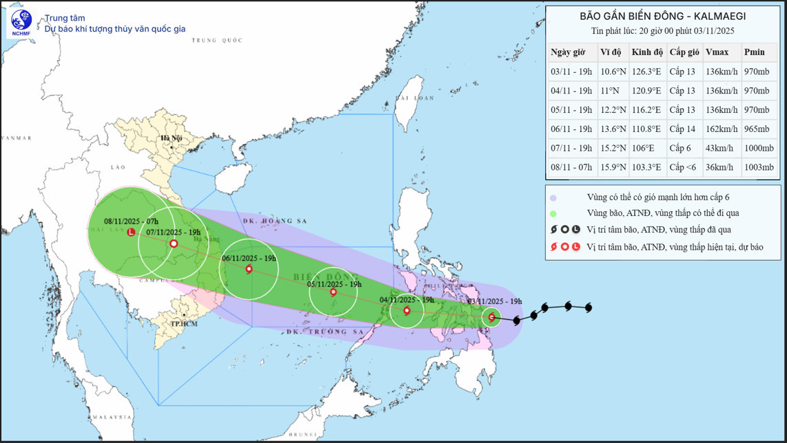
By 7:00 PM on November 3, the center of Typhoon Kalmaegi was located along the eastern coast of central Philippines. Maximum sustained winds near the center were 73-93 mph (Level 12-13), with gusts up to 99 mph (Level 16). The typhoon was moving westward at a rapid speed of approximately 25 km/h (15.5 mph).
In the next 24 hours, the storm is expected to continue westward at the same pace. By 7:00 PM on November 4, its center will be over the central Philippines with maximum winds of Level 13, gusting to Level 16.
Between 24 to 48 hours later, Kalmaegi will move west-northwest at 20-25 km/h (12-15.5 mph), entering the East Sea. By 7:00 PM on November 5, the storm will be positioned in the central East Sea, about 800 km (500 miles) southeast of the Vietnamese province of Gia Lai. Its wind speed is forecast to remain at Level 13 with gusts up to Level 16 and may intensify further.
In the following 24 hours (up to 7:00 PM on November 6), the storm will approach the waters off Quang Ngai to Dak Lak, located about 200 km (124 miles) southeast of Gia Lai. It is projected to reach its peak intensity with sustained winds at Level 14 and gusts reaching Level 17 (approximately 121-132 mph).
From 72 to 108 hours onward, Kalmaegi is expected to continue moving west-northwest at 20-25 km/h while gradually weakening in intensity.
Fierce seas, extreme winds ahead
Due to Kalmaegi’s influence, by the afternoon of November 4, the eastern region of the central East Sea will see increasing wind strength, reaching Level 6-7 (39-61 km/h or 24-38 mph), later rising to Level 8-10 (62-88 km/h or 39-55 mph). Near the storm's center, winds will reach Level 11-13 (89-117 km/h or 55-73 mph), with gusts up to Level 15-16. Waves are forecast to reach heights of 5-7 meters (16-23 feet), creating extremely rough sea conditions.
Between November 5 and 6, the central East Sea (including the Spratly Islands) and offshore waters from Da Nang to Khanh Hoa will likely face powerful winds at Level 12-14, with gusts over Level 17 (up to 150 km/h or 93 mph). Waves could reach 8-10 meters (26-33 feet), resulting in dangerous marine conditions.
All vessels and offshore structures within the affected areas will be subject to severe impacts from thunderstorms, tornadoes, strong winds, and giant waves.
Bao Anh