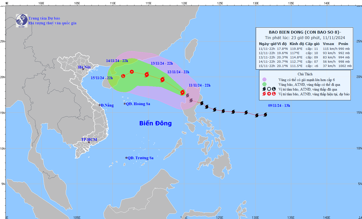
Typhoon Toraji has moved into the northeastern East Sea, becoming the eighth storm of 2024. According to forecasts, it is expected to weaken rapidly and dissipate at sea within the next 2-3 days.
The National Center for Hydro-Meteorological Forecasting reports that as of 10:00 p.m. on November 11, the storm’s center was located in the northeastern area of the East Sea. The strongest winds near the center were reaching levels of 11 on the Beaufort scale (103-117 km/h), with gusts up to level 13. The storm is moving northwest at approximately 20 km/h.
Over the next 24 hours, Typhoon Toraji is forecast to maintain its direction but will slow to a speed of 15-20 km/h. By 10:00 p.m. on November 12, its center is expected to still be located in the northeastern East Sea but with reduced intensity at levels 9-10, with gusts reaching level 12.
After this, the storm is predicted to shift to a west-northwest course at 10-15 km/h, continuing to lose strength. By 10:00 p.m. on November 13, the storm’s center will be in the northern section of the East Sea with wind speeds down to levels 8-9, and gusts at level 11.
As it continues to drift north within the East Sea, Typhoon Toraji will gradually weaken into a tropical depression, moving at around 10 km/h.
Over the subsequent 72 to 96 hours, the tropical depression is forecast to move west-southwest at approximately 5 km/h, with further weakening.
Thus, after entering the East Sea, Typhoon Toraji (Storm No. 8) is expected to weaken swiftly and dissipate over open waters.
However, due to the storm’s influence, the northeastern area of the East Sea will experience strong winds at levels 6-7, increasing to level 8, with gusts near the storm center reaching levels 9-11 and gusts at level 12. Wave heights will reach 3-5 meters, with peaks up to 5-7 meters near the center, resulting in highly turbulent seas.
All vessels operating in these hazardous areas are at risk of severe thunderstorms, strong winds, and large waves.
Meteorologists have also noted the potential for a ninth storm, as a tropical depression and a distant typhoon are currently active off the coast of the Philippines.
Bao Anh