 Vietnamnet.vn

 Podcast



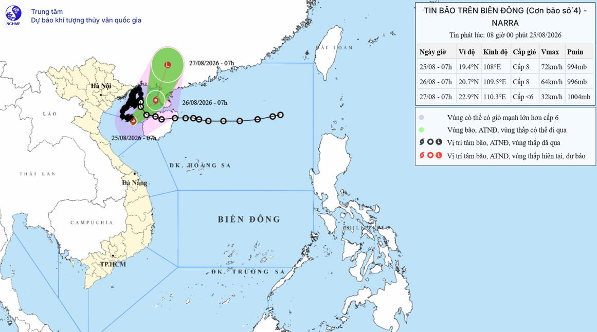
Maximum sustained winds near the storm’s center were at Level 8, or 62-74 kph, with gusts reaching Level 10. The typhoon was moving south-southeast at 5-10 kph.
Over the next 24 hours, Narra is forecast to move slowly before turning east-northeast, continuing farther offshore and weakening.
By 7 a.m. on Aug. 26, the storm’s center is forecast to be over the eastern Gulf of Tonkin, around 210 km east-northeast of Bach Long Vi. Its strength is expected to remain at Level 8, with gusts at Level 10.
Over the following 24 hours, the storm is expected to change direction again, moving north-northeast at a faster speed of around 10 kph. It is forecast to gradually weaken into a tropical depression and then a low-pressure area over Guangxi, China, with winds below Level 6.
Under the influence of Typhoon Narra, the Gulf of Tonkin, including Bach Long Vi, is experiencing winds of Level 6-7, rising to Level 8 near the storm’s center, with gusts at Level 10. Waves are 2-4 meters high, with rough seas.
Vessels operating in the affected waters could face thunderstorms, tornadoes, strong winds and high waves.
Rainfall drops sharply across northern Vietnam
The weather agency said rainfall across northern Vietnam had decreased significantly as Narra moved farther offshore. Most areas in Lang Son, Thai Nguyen and Bac Ninh were no longer seeing rain.
Some locations were still recording rainfall of 40-70 mm, mainly in the northwestern region and the coastal provinces of Thanh Hoa, Nghe An and Ha Tinh.
Most of northern Vietnam is expected to see little or no rain on Aug. 25. Coastal areas from Thanh Hoa to Ha Tinh are forecast to receive 20-40 mm, with isolated rainfall exceeding 80 mm.
Floodwaters recede on many rivers
In Lang Son and Thai Nguyen, river levels are falling. The Cau River in Thai Nguyen has dropped below Level 1, the lowest of Vietnam’s three flood warning levels.
In Bac Ninh, the Cau, Thuong and Luc Nam rivers remain at Level 3, the highest warning level, although water levels are forecast to continue falling during the day.
On the Buoi River in Thanh Hoa, the water level at Kim Tan peaked at 11.7 meters on the morning of Aug. 25, 0.3 meters below Level 3, before beginning to fall slowly.
On the Hoang Long River in Ninh Binh, the water level at Ben De is forecast to fall to 3.1 meters during the day, 0.1 meters above Level 1.
In Nghe An, flooding on rivers in upstream areas is currently at Level 1 and is forecast to continue rising while remaining below Level 2. Flood developments will also depend on water releases from reservoirs.
Overall, Typhoon Narra is weakening and moving farther offshore, while rainfall has fallen sharply across northern Vietnam. However, some areas still face a risk of flooding as river levels remain high.
According to Hanoi’s Sub-Department of Irrigation and Disaster Prevention and Control, water levels on several rivers across the capital remained high as of 5 a.m. on Aug. 25.
The Cau River at Luong Phuc station was 0.52 meters above Level 3. The Tich River was 0.22 meters above Level 3 at Kim Quan station and 0.1 meters above it at Vinh Phuc station. The Bui River at Yen Duyet station was 0.03 meters above Level 3, while the Ca Lo River at Manh Tan station was 0.97 meters above Level 2 and close to Level 3.
Water levels on the Da, Red and Duong rivers remained well below Level 1.
Water levels at several irrigation reservoirs, including Dong Mo, Quan Son, Tan Xa, Xuan Khanh, Ban Tien and Keo Ca, have reached their spillway thresholds. Dong Mo reservoir is currently releasing water through four spillway gates, while Quan Son is overflowing naturally.
According to the Vietnam News Agency, Hanoi’s Civil Defense Command issued Flood Alert No. 19/L-BCH on the evening of Aug. 24. At 6:40 p.m. that day, the Tich River at Kim Quan reached 8.42 meters, 0.02 meters above the Level 3 warning threshold.
The city issued a Level 3 flood alert for the Tich River and instructed local authorities, relevant agencies and response forces to strictly implement measures required for the warning level.
Bao Anh-Vu Diep
.svg)
