Heavy rain from Storm No. 7, Yinxing, has affected areas from Thua Thien Hue to Binh Dinh. Forecasts suggest that within the next 24-48 hours, Typhoon Toraji could enter the East Sea as Storm No. 8, and there is a possibility of yet another storm forming as Storm No. 9.
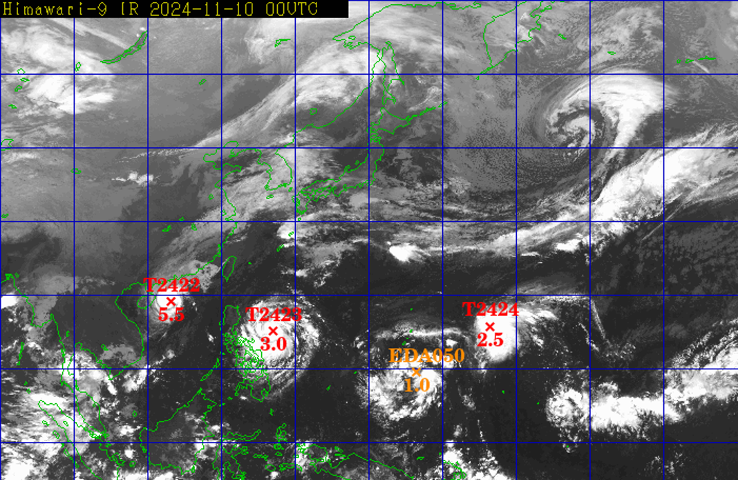
On November 10, Nguyen Van Huong, Head of Weather Forecasting at the National Center for Hydro-Meteorological Forecasting, reported that three typhoons are currently active in the Pacific.
The first is Storm No. 7, Yinxing, located in the East Sea of Vietnam, followed by Typhoon Toraji east of the Philippines, and another storm, Man-yi, far off in the northwest Pacific.
Additionally, a tropical depression is positioned between Typhoons Toraji and Man-yi.
According to Mr. Huong, these three storms and the tropical depression lie along an intertropical convergence zone that passes through the northern East Sea.
Storms or tropical depressions that form along this convergence zone typically move along its path, explaining the continued arrival of tropical cyclones in the East Sea.
Currently, Storm No. 7 is active, and in the next 24-48 hours, Storm No. 8 may emerge, with the possibility of Storm No. 9 following soon after.
Mr. Huong added that Typhoon Toraji is likely to move into the East Sea between late tomorrow afternoon and evening (November 11).
Experts also explained that the western Pacific is currently warm and humid, providing ample energy to fuel storms, cyclones, and tropical depressions, which has led to the sequence of storms we are seeing.
Additionally, forecasts indicate that November and December will see continued warm sea temperatures, raising the likelihood of more tropical depressions and storms. Currently, the La Niña effect remains mild (just above neutral), but if it intensifies, the region may experience an increase in tropical depressions and storms.
With these recurring storms, dangerous weather in the northern and central East Sea areas is expected, with strong winds, high waves, and turbulent seas persisting over an extended period.
Apart from the storms, a strong northeast monsoon is expected within the next 5-10 days, further contributing to strong winds and high waves at sea.
Storm No. 7 brings heavy rain from Thua Thien Hue to Binh Dinh

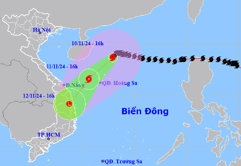
By 4:00 PM on November 10, the eye of Storm No. 7 was located in the western area of the northern East Sea, approximately 230 km northeast of the Hoang Sa Archipelago. The maximum sustained winds near the storm’s center were at level 12 (118-133 km/h), with gusts reaching level 14. The storm is moving southwest at about 5 km/h.
In the next 24 hours, the storm is expected to maintain this direction while accelerating to 10-15 km/h and gradually weakening. By 4:00 PM tomorrow (November 11), the storm center is forecasted to be in the western waters of the Hoang Sa Archipelago, with its strength reduced to level 8, gusting to level 10, and then weakening into a tropical depression.
By 4:00 PM on November 12, the tropical depression is projected to dissipate into a low-pressure area over land from Quang Ngai to Binh Dinh.
Due to the storm's influence, from early November 12 to 13, areas from Thua Thien Hue to Binh Dinh may experience moderate to heavy rains, with some areas seeing exceptionally heavy rainfall, accumulating between 70-150 mm, and localized amounts over 250 mm. Heavy rain is expected to decrease gradually after November 13.
The western waters of the northern East Sea (including the Hoang Sa Archipelago) will experience strong winds at levels 7-9, with areas near the storm's center reaching levels 10-12, gusting to level 14, and waves reaching heights of 3-5 meters, with up to 5-7 meters near the center, resulting in extremely turbulent seas.
From tomorrow morning, coastal waters from Thua Thien Hue to Binh Dinh will see winds increasing to levels 6-7, gusting to level 9, and waves 2-4 meters high, with rough seas.
All vessels operating in these hazardous areas will likely be affected by thunderstorms, strong winds, and large waves.
National weather outlook (November 9-15)
The National Center for Hydro-Meteorological Forecasting has forecasted dry weather in the North, with light morning fog and sunny days.
In the Central region, scattered rain and thunderstorms are expected, with moderate to heavy rains and thunderstorms likely in the Central Coast from November 12-13, accompanied by tornadoes, whirlwinds, and strong gusts. Rivers in Central and South-Central regions may see fluctuations, while rivers in North-Central areas are expected to change slowly.
The Central Highlands and southern regions will also see scattered rain and thunderstorms, with the southwest experiencing scattered rain and thunderstorms from the evening of November 9-10.
Hanoi’s weather remains dry, with light morning fog and sunshine throughout the day.
Bao Anh