According to the National Center for Hydro-Meteorological Forecasting, October saw numerous extreme weather events in the East Sea and across Vietnam’s mainland. These included Tropical Storm Matmo (Storm No. 11), Fengshen (Storm No. 12), and a tropical depression.
October also experienced three cold air surges on October 19, 26, and 30. The first brought level-7 winds (gusting to level 9) in Bach Long Vi and Con Co, while plunging temperatures in the north, with some mountainous areas dropping below 9°C. The following two cold spells were dry and accompanied by strong northeasterly winds, which, combined with storm circulation and easterly disturbances, triggered widespread rainfall from the north to the central region.
Notably, from southern Nghe An to Quang Ngai, the central region endured three major rain events in October. The final one, from October 23 to 31, brought rainfall ranging from 150 to 450mm, with some areas exceeding 550mm. In Hue and Da Nang, historical records were broken: Nam Dong (Hue) recorded 1,772mm, Tra My (Da Nang) 1,545mm, and A Luoi (Hue) 1,236mm. In many locations, daily and monthly rainfall totals surpassed historical averages for the same period.
Nationwide, October’s total rainfall exceeded the multi-year average by 20 to 90 percent. In the northeast and the stretch from Quang Tri to Hue, levels were 3 to 5 times higher than average.
Meanwhile, national average temperatures were about 0.5 to 1°C higher than usual.
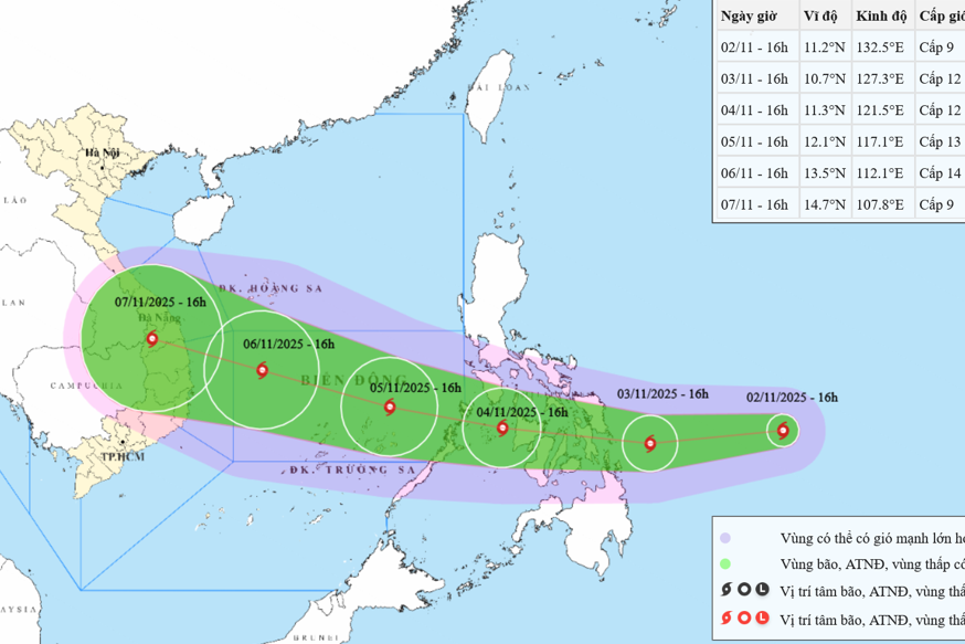
Specifically, 2 to 3 more storms or tropical depressions are expected to form over the East Sea, with 1 or 2 likely to directly impact Vietnam’s mainland. Historically, the average for November is 1.5 storms forming in the East Sea, with 0.9 making landfall in Vietnam.
At the same time, cold air outbreaks will increase in both frequency and intensity, significantly affecting northern and north-central Vietnam.
From Ha Tinh to Dak Lak and Khanh Hoa, multiple rounds of heavy rainfall are likely. The western region of Lam Dong and the southern provinces will also see frequent showers and thunderstorms, with some days bringing moderate to heavy rainfall.
For November, the national average temperature is forecast to be about 0.5°C lower than the multi-year average. From Nghe An to Hue, the drop may reach 0.5 to 1°C.
“Dangerous weather phenomena like thunderstorms, whirlwinds, lightning, hail, and strong gusts remain likely nationwide,” meteorologists warned.
“Storms, tropical depressions, and cold air surges will also trigger strong winds and large waves at sea, disrupting maritime activity. Heavy rainfall could lead to flash floods, inundation in low-lying areas, and landslides in mountainous terrain.”
Experts stress that climate change is making extreme weather events such as short-duration heavy rains, flash floods, and landslides more frequent and severe.
Authorities and residents are urged to closely monitor forecasts and short-term warnings (1–3 days), proactively adjust production plans, manage reservoirs effectively, and implement preparedness measures to protect infrastructure, downstream areas, and livelihoods.
Bao Anh