When the Can Gio - Vung Tau UAV delivery route officially took off, the question was no longer whether to fly, but how to govern the sky without slipping into extremes.
Ho Chi Minh City now faces a difficult choice. If the low-altitude economy, or LAE, is to become a new growth engine, the city must decide how to open that space without falling into two undesirable states.
One is to rush ahead in the excitement of technological and logistics opportunities without a solid legal and data foundation. The other is to move so cautiously, out of security concerns, that opportunities narrow before they can be realized.
When “flying” is not yet the default
LAE is therefore not simply a story about aircraft that can fly. It is a test of institutional capacity, data infrastructure and the city’s readiness to socialize a space that has long been tightly controlled.
According to Dr. Le Net of LNT & Partners Law Firm, LAE can be understood in simple terms as economic activity conducted below 1,000 meters, as airspace above that altitude belongs to aviation and aerospace.
In many countries, the threshold is set below 3,000 meters, with some definitions extending to under 5,000 meters. However, he noted that the concept has yet to be defined in the 2025 Aviation Law, which will take effect on July 1, and expressed hope that it will be clarified in the implementing decree.
This small legal gap illustrates a broader point: developing LAE in Vietnam is not merely a technological issue, but first and foremost a governance challenge.
“At present, applying for flight permits remains difficult. We have not reached a stage where flying is allowed by default as long as aircraft avoid prohibited or restricted zones. Registration procedures are not simple. There are no clear standards for aircraft, registration, insurance or pilot certification,” Le Net said candidly.
He cited China’s model, where same-day licensing has been implemented in six major cities, supported by ready infrastructure for unmanned aircraft traffic management systems connected to traditional air traffic management.
For him, the answer is neither speed nor delay in isolation, but preparation. Once ready, move quickly - as quickly as possible - to seize opportunities. If not ready, pilot first.
Le Net proposed that Vietnam open regulatory sandboxes in Ho Chi Minh City, Da Nang and Hue, similar to China’s approach. “From a legal perspective, we need a decree guiding the 2025 Aviation Law to legitimize pilot programs in 2026,” he emphasized.
His principle is clear: encourage private sector participation in all areas except those explicitly prohibited or restricted. Prohibited and restricted zones should be publicly disclosed to the extent possible and managed by area.
Then comes the need to build an unmanned traffic management system. “Instead of prohibition being the default, we must move toward flying being the default, and prohibition the exception,” he summarized, capturing a shift in mindset.
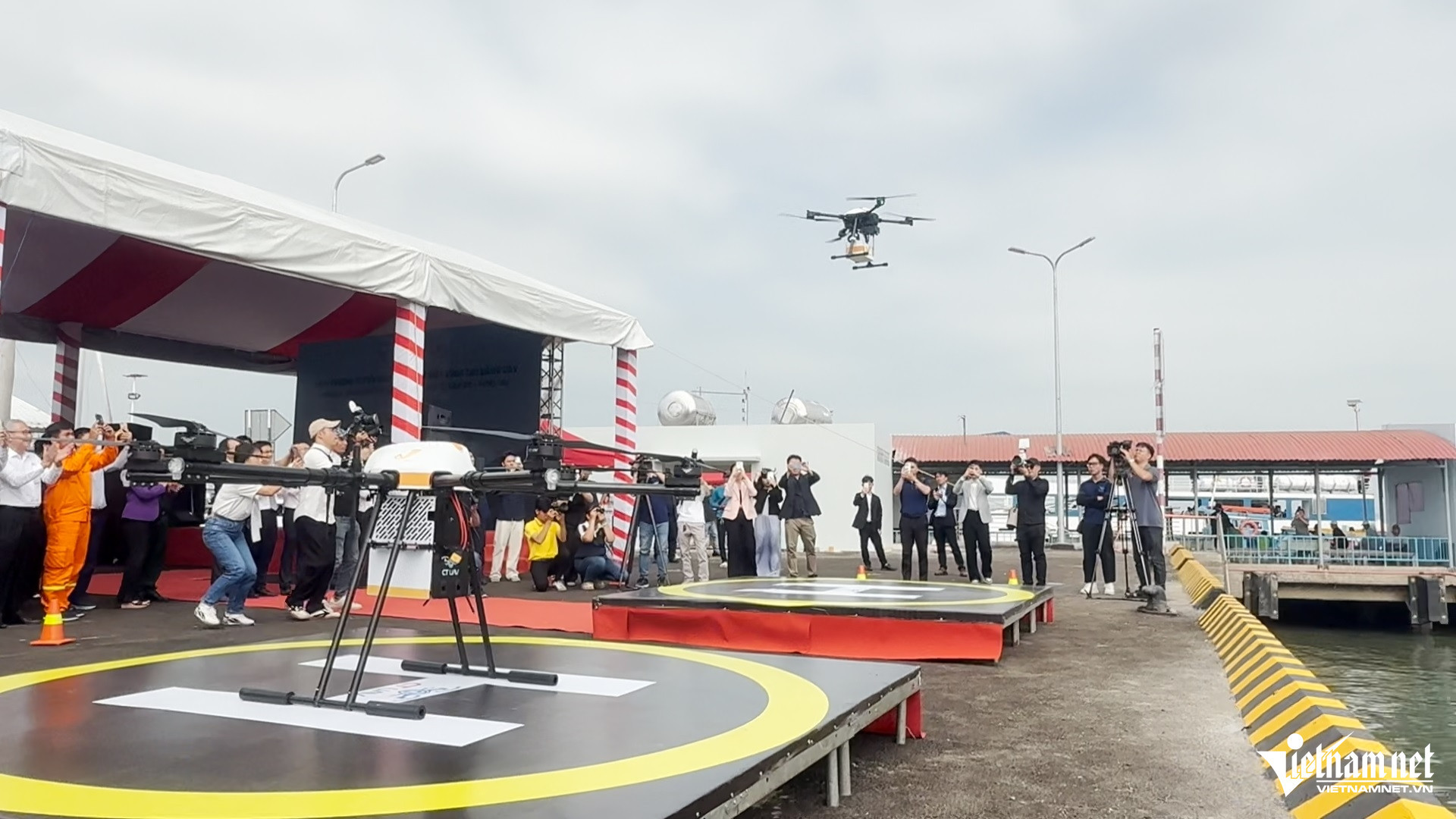
While the legal corridor awaits completion, Ho Chi Minh City has made a notable move. Lam Dinh Thang, Director of the city’s Department of Science and Technology, said the city leveraged a special mechanism to officially launch Vietnam’s first UAV delivery route connecting postal services between Can Gio Commune and Vung Tau Ward on February 12.
Earlier, in November 2025, the department coordinated with the High-Tech Park Management Board to conduct limited trial flights.
“If the earlier trial was an important rehearsal, the newly launched route is a breakthrough step. This flight covered a longer distance, operated under more complex conditions, including strong winds and over-sea segments,” Thang said.
The milestone demonstrates HCMC’s determination to bring scientific and technological achievements into daily life, foster innovation and develop the digital economy. It also lays the groundwork for applying unmanned aerial vehicles in urban postal and logistics operations.
Necessary and sufficient conditions to socialize the sky
Yet these pioneering steps have also exposed bottlenecks across the LAE ecosystem. Dr. Luong Viet Quoc, CEO of Real-time Robotics JSC, pointed to the lack of minimum foundational layers for piloting and operational research.
“Despite positive signals, we are still falling behind due to institutional barriers. For example, importing essential R&D equipment such as Wifi 6 transmission modules, a globally commercialized technology, remains restricted. This forces companies to conduct related R&D abroad, increasing costs and reducing competitiveness. We also lack licensed testing corridors, especially for long-range flights, which delays product testing and refinement,” he said.
Beyond legal frameworks and governance principles, scientists stress the importance of data infrastructure. Associate Professor Dr. Le Trung Chon, Director of the Institute for Sustainable Development Research, argued that LAE is not simply about flying.
“Its essence lies not in the vehicle, but in how we manage low-altitude space, data and risk. That space is far from empty. It is directly linked to housing, infrastructure, people, security and privacy,” he said.
He views geospatial intelligence, or GeoINT, as a prerequisite. Drawing on experience applying remote sensing and GIS to monitor urban land subsidence, manage construction order and analyze COVID-19 case distribution, he concluded: “A smart city does not begin with flashy technology, but with the ability to understand urban space through reliable data. If we do not master the ground with GeoINT, then all aerial activities, including LAE, lack a stable foundation.”
Sharing this line of thinking, Associate Professor Dr. Huynh Quyen, President of Ho Chi Minh City University of Natural Resources and Environment, said focusing solely on vehicles while ignoring foundations is like building castles on sand. In his view, LAE rests on three pillars: GeoINT, institutional capacity and ethical governance.
“Going a little slower to avoid going wrong is not hesitation or restraint. It is necessary maturity in thinking,” he said. Slowing down allows time to accumulate data, complete legal corridors and, most importantly, build social trust.
Here, the State’s role is not merely to issue licenses, but to act as ecosystem architect - investing in foundational data infrastructure, establishing clear rules of the game and ensuring transparent risk governance.
From different angles, it is clear that socializing the sky - mobilizing the private sector to participate in infrastructure, operations and services - is not simply about opening a few drone routes.
The first necessary condition is a clear legal corridor. The second is management infrastructure, including an unmanned traffic management system connected to traditional air traffic control, along with digitalized, publicly accessible maps of prohibited and restricted zones where possible.
The third is interoperable 3D geospatial data capable of understanding and managing the city as a living, complex entity, as GeoINT experts emphasize.
The sufficient condition may lie in something less tangible: trust. Trust that innovation does not conflict with national security, that enterprises can partner with the State under PPP models, that data is governed transparently, and that the city’s long-term interests outweigh short-term gains.
Ho Chi Minh City has taken off. But for LAE to truly become a new economic layer of this super metropolis, the city needs more than technology that can fly. It needs an ecosystem that can govern.
Opening the sky, in the end, is not a technical act. It is an institutional choice.
And as experts repeatedly stress, if forced to choose between moving fast and risking mistakes or moving slowly and missing opportunities, then for a complex and vulnerable urban center like Ho Chi Minh City, maturity may still be the safest path to rise.
Quoc Ngoc