 Vietnamnet.vn

 Podcast



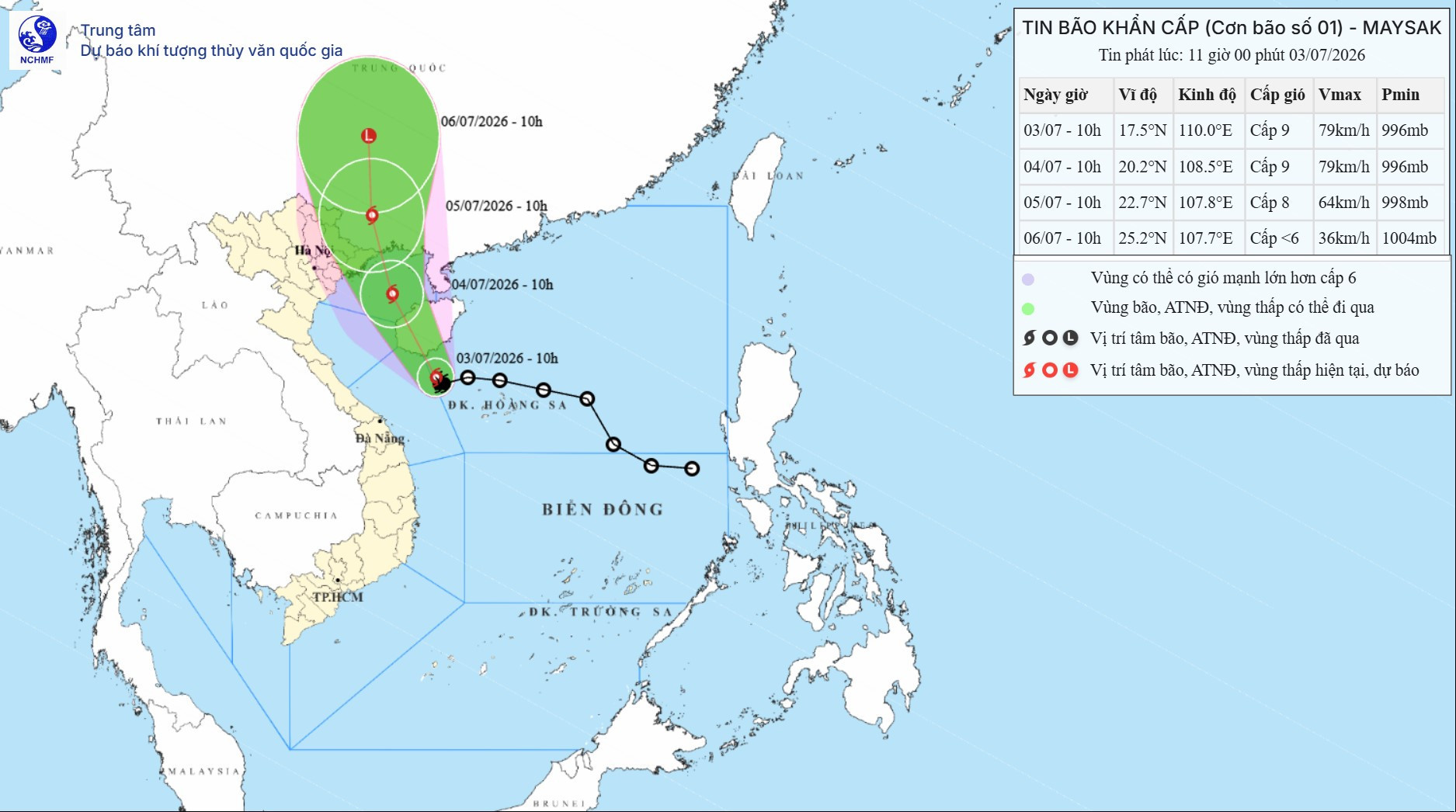
According to Vietnam's National Center for Hydro-Meteorological Forecasting (NCHMF), as of 10 a.m. on July 3, the storm's center was located about 90 kilometers south of Hainan Island, China. Maximum sustained winds near the eye had strengthened to force 8-9 (62-88 km/h), with gusts reaching force 11, nearly one category stronger than earlier in the morning. The storm was moving slowly west-northwest at around 5 km/h.
Over the next 24 hours, the storm is forecast to turn north-northwest and accelerate to 10-15 km/h. By 10 a.m. on July 4, its center is expected to be over the northern Gulf of Tonkin, about 170 km southeast of Mong Cai in Quang Ninh Province and around 220 km southeast of mainland Quang Ninh, while maintaining force 8-9 winds with gusts up to force 11.
During the following 24 hours, Maysak is forecast to maintain both its direction and speed. By 10 a.m. on July 5, the storm's center is expected to move into southern Guangxi Province, China, weakening to force 8 with gusts up to force 10.
Afterward, the storm is forecast to turn northward at 10-15 km/h before weakening into a tropical depression and eventually a low-pressure area over southern Guangxi.
Under the storm's influence, the western waters of the northern East Sea, including the Hoang Sa (Paracel) special zone, are experiencing force 6-7 winds, increasing to force 8-9 with gusts up to force 11 near the storm's center. From the night of July 3, the affected area is expected to expand into the Gulf of Tonkin, including the Bach Long Vi special zone, Van Don, Co To, Cat Hai and Hon Dau Island. Waves are forecast to reach 2-4 meters, with very rough seas.
From the afternoon of July 4, coastal areas of Quang Ninh, Hai Phong and Hung Yen are forecast to experience force 6 winds, strengthening to force 7-8 near the storm's center, with gusts of force 9-10. Waves of 2-3 meters are expected, combined with a storm surge of around 0.2-0.4 meters.
Eleven northern localities step up storm preparedness
Vietnam's National Steering Committee for Civil Defense has issued an urgent directive to the People's Committees of Quang Ninh, Hai Phong, Hung Yen, Ninh Binh, Thanh Hoa, Lang Son, Cao Bang, Ha Giang, Bac Ninh, Thai Nguyen and Hanoi, ordering them to proactively prepare for Typhoon No. 1 and post-storm flooding.
According to forecasts, Maysak developed from a tropical depression on the morning of July 3, reaching force 8 with gusts up to force 10 before moving toward the Gulf of Tonkin.
From the night of July 3 through July 5, northeastern Vietnam and Thanh Hoa are forecast to receive widespread rainfall of 100-200 mm. Some parts of the Northeast could record 150-250 mm, with isolated locations receiving more than 350 mm.
The steering committee has instructed local authorities to monitor and account for all fishing vessels, prepare to impose sea bans if necessary, ensure the safety of anchorages, and ready search-and-rescue forces.
On land, authorities have been directed to review and evacuate residents from high-risk areas, ensure the safety of dikes, reservoirs and critical infrastructure, while also taking proactive measures to prevent flooding and protect agricultural production.
Government ministries, agencies and local authorities have also been instructed to closely monitor the storm's development, maintain round-the-clock emergency operations and remain prepared for all possible scenarios.
Bao Anh
.svg)
