 Vietnamnet.vn

 Podcast



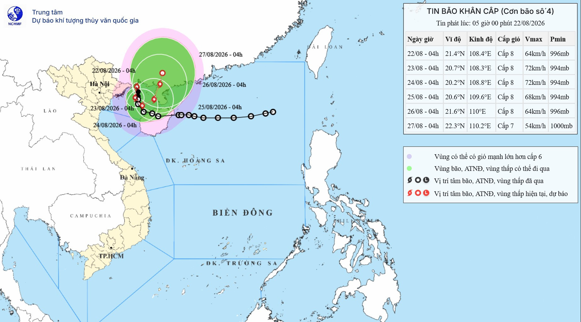
According to the National Center for Hydro-Meteorological Forecasting (NCHMF), a tropical depression over the northern Gulf of Tonkin strengthened into Vietnam’s fourth storm of the year on the evening of August 21.
The storm has the international name Narra, contributed by the Philippines. Narra is a hardwood tree and the national tree of the Philippines.
By 7 a.m. on August 22, the storm’s center was at approximately 21.3 degrees north latitude and 108.2 degrees east longitude, over waters off Quang Ninh and Hai Phong and about 140km north-northeast of Bach Long Vi.
Maximum sustained winds near its center reached Level 8, or 62-74km/h, with gusts at Level 10. The storm was moving west at around 5km/h.
Narra’s effects were already being felt along Vietnam’s northern coast. Bach Long Vi in Hai Phong recorded Level 8 winds with Level 9 gusts, while Co To in Quang Ninh experienced Level 6 winds and Level 9 gusts. Mong Cai station in Quang Ninh recorded Level 7 winds, while Phu Lien station in Hai Phong reported Level 6 winds with Level 7 gusts.
What makes Narra particularly unusual is how slowly and erratically it is moving.
From the night of August 21 into the morning of August 22, the storm traveled at only around 3-5km/h, initially moving north before turning west. Forecasts indicate that it will continue at roughly the same sluggish pace over the coming days while repeatedly changing direction.
From August 22 into the morning of August 23, the storm is forecast to move mainly south-southwest before turning southeast and then east-northeast, while maintaining Level 8 winds and Level 10 gusts.
After entering waters off Quang Ninh and Hai Phong, it is expected to move back into the Gulf of Tonkin within 24 hours and linger there for another two to three days.
Mai Van Khiem, Director of the NCHMF, said the storm is moving slowly because the steering currents surrounding it are weak, leaving the system without a clear force pushing it in one direction.
As a result, Narra is effectively wandering around the Gulf of Tonkin, moving back and forth and at times nearly becoming stationary.
The unusual pattern could keep weather conditions at sea and along the coast highly unpredictable while prolonging heavy rainfall across northern Vietnam, particularly the Northeast. It also increases the risk of flash floods and landslides in mountainous areas.
Forecasts indicate that Narra could continue changing direction through August 25 while maintaining winds of around Level 8 and gusts at Level 10.
Over the following 72-120 hours, the storm may turn north-northeast, continue moving at just 3-5km/h and gradually weaken into a tropical depression.
Heavy rain spreads across northern Vietnam
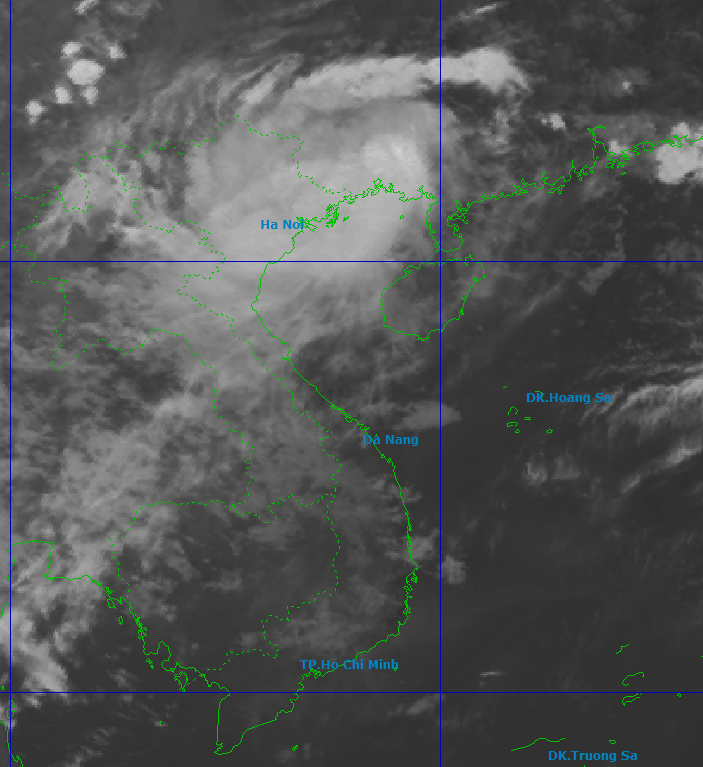
Nguyen Van Huong, head of the Weather Forecasting Department at the NCHMF, said forecasting models indicate that the heaviest rainfall will initially be concentrated in the Northeast before tending to spread southward toward Thanh Hoa and the northern part of north-central Vietnam.
Quang Ninh, Hai Phong, Lang Son, eastern Bac Ninh and coastal areas of Hung Yen and Ninh Binh could experience heavy to extremely heavy rain.
The mountainous areas of Cao Bang, Lang Son and Quang Ninh face the risk of localized extreme rainfall, accompanied by heightened threats of flash floods and landslides.
In north-central Vietnam, rainfall could also concentrate in Nghe An and Ha Tinh.
Tran Tuan Kien, Deputy Director of the Institute of Meteorology, Hydrology, Environment and Sea, also identified Cao Bang, Lang Son, mountainous Quang Ninh and parts of north-central Vietnam, particularly Nghe An and Ha Tinh, as areas requiring close attention.
From August 22 through the night of August 24, the Northeast, southern Phu Tho and Thanh Hoa are forecast to receive 100-200mm of rain, with localized totals exceeding 400mm.
Quang Ninh and Hai Phong face considerably heavier rainfall of 250-350mm, with isolated areas receiving more than 600mm. Lang Son and Bac Ninh are forecast to receive 200-300mm, with localized totals exceeding 500mm.
Rain could continue beyond the night of August 24.
Meteorological authorities warned that prolonged downpours could inundate urban areas, industrial zones and low-lying locations while raising water levels in small rivers and streams.
Mountainous areas face growing risks of flash floods and landslides, while thunderstorms, tornadoes and powerful wind gusts are also possible under the influence of the storm’s circulation.
Dangerous seas, Quang Ninh suspends vessel permits
Across the Gulf of Tonkin, including Bach Long Vi, Van Don, Co To, Cat Hai and Hon Dau Island, winds are forecast at Level 6-7, increasing to Level 8 near the storm’s center with Level 10 gusts.
Waves could reach 2-4 meters, producing rough seas.
The dangerous conditions could capsize, sink or damage fishing boats, cargo vessels, tourist boats and other craft. Aquaculture cages, vessel anchorages and coastal infrastructure are also at risk, while fishing, maritime transport and tourism activities could be disrupted.
Coastal areas of Quang Ninh and Hai Phong are forecast to experience Level 6-7 winds with gusts reaching Level 8-9.
In response, Quang Ninh’s Department of Agriculture and Environment announced on August 22 that it had temporarily suspended permits for vessels to head out to sea.
Relevant agencies and coastal authorities were instructed to stop issuing permits for vessels that do not meet safety requirements and to consider allowing vessels already offshore to return to safe shelters.
Permits for sightseeing and overnight stays at sea were also temporarily suspended.
The restrictions took effect at 7 a.m. on August 22 and will remain in place until the final storm bulletin is issued.
More storms could develop over the next month
Narra comes as forecasters warn that weather conditions could remain complicated in the weeks ahead.
According to the NCHMF’s climate outlook for August 21 to September 20, tropical storm and tropical depression activity in the East Sea is expected to remain broadly in line with the long-term average.
Historical averages for the period are around 2.4 storms or tropical depressions in the East Sea, with about 1.1 making landfall in Vietnam.
That means roughly two to three storms or tropical depressions could develop over the next month, with one potentially making landfall in Vietnam.
Rainfall across northern Vietnam and the region from Thanh Hoa to Quang Tri is forecast to be around 10-30% above the long-term average.
Widespread heavy rain during the period is expected to be concentrated mainly in the North and the area from Thanh Hoa to Hue.
Authorities have warned that storms, tropical depressions and severe thunderstorms could cause flooding, flash floods and landslides, disrupting transport, production and daily life.
At sea, vessels also need to remain alert to strong winds and high waves associated with thunderstorms, the southwest monsoon and tropical cyclones.
Bao Anh
.svg)
