 Vietnamnet.vn

 Podcast



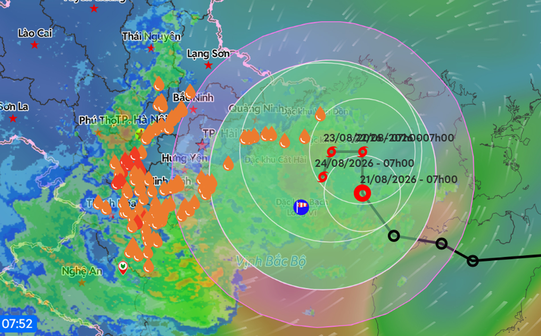
As of 7am on August 21, the center of the tropical depression was over the northern Gulf of Tonkin, about 100km east of Bach Long Vi Special Zone. Maximum sustained winds near its center were at Force 7, or 50-61km/h, with gusts reaching Force 9. The system was moving mainly northwest at around 5km/h.
Meteorologists said that after entering the Gulf of Tonkin, the tropical depression is highly likely to strengthen into a storm - the fourth to affect Vietnam this year - with winds reaching Force 8 and gusts of Force 10.
At the same time, the storm is expected to slow to just 3-5km/h as it heads toward the northeastern mainland before gradually weakening back into a tropical depression. However, because the system is moving so slowly, the risk of prolonged heavy rain across northeastern Vietnam is particularly high.
Over the next 24 hours, the tropical depression is forecast to change direction and move north at around 3-5km/h, with the potential to intensify into a storm.
By 7am on August 22, the storm's center is expected to be over the northern Gulf of Tonkin, about 190km east of Hai Phong and around 120km northeast of Bach Long Vi Special Zone. It is forecast to reach Force 8, with gusts of Force 10.
During the following 24 hours, Storm No. 4 is expected to change direction again, moving west at the same slow speed of 3-5km/h. By 7am on August 23, its center is forecast to remain over the northern Gulf of Tonkin, around 150km east of Hai Phong and about 100km north of Bach Long Vi Special Zone. Its intensity is expected to remain at Force 8, with gusts of Force 10.
During this period, a Level 3 natural disaster risk warning will be in place for the Gulf of Tonkin, including Bach Long Vi, Van Don, Co To and Cat Hai special zones, as well as Hon Dau Island.
Over the subsequent 48-72 hours, the storm could change direction once more, moving slowly southward at 3-5km/h.
Under the influence of the tropical depression, which is expected to strengthen into a storm, winds across the Gulf of Tonkin, including Bach Long Vi Special Zone, are forecast to increase to Force 6-7. Areas near the storm's center could see Force 8 winds and Force 10 gusts. Waves are expected to reach 2.5-3.5m, with rough seas.
Vessels operating in the affected waters could face thunderstorms, tornadoes, strong winds and high waves.
Warning of 120mm of rain in three hours
Under the combined influence of the intertropical convergence zone, moderate to heavy rain and thunderstorms affected northeastern Vietnam and areas from Thanh Hoa to Nghe An overnight and on the morning of August 21, with extremely heavy rain recorded in some locations.
Rainfall between 7pm on August 20 and 8am on August 21 exceeded 100mm at several monitoring stations, including Ban Hang Doi in Phu Tho with 155mm, Thanh Ha in Hanoi with 122.8mm and Vinh Thinh in Thanh Hoa with 109.4mm.
From August 21 through the end of the night of August 22, northeastern Vietnam and Thanh Hoa are forecast to continue experiencing moderate to heavy rain and thunderstorms. Widespread rainfall of 70-150mm is expected, while some locations could receive more than 300mm. Authorities have warned that rainfall intensity could exceed 120mm within just three hours.
Nghe An is also forecast to see moderate to heavy rain and thunderstorms on August 21, with widespread totals of 20-40mm and isolated areas receiving more than 80mm.
Meteorological authorities said that from August 23, northeastern Vietnam and Thanh Hoa are expected to continue seeing moderate to heavy rain and thunderstorms, with extremely heavy rainfall possible in some places. The wet conditions could persist.
Residents in northeastern provinces and northern mountainous areas have been advised to prepare for the risk of flooding and landslides.
Bao Anh
.svg)
