 Vietnamnet.vn

 Podcast


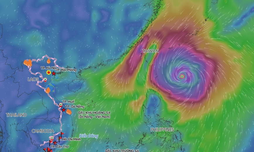
Super Typhoon Champi began affecting the eastern waters of the northern East Sea on October 22, bringing strong winds, rough seas and hazardous conditions for vessels, according to Vietnam's National Center for Hydro-Meteorological Forecasting.
Although the storm is forecast to remain outside the East Sea, its extensive circulation is producing dangerous marine conditions across the region.
Waves of up to six meters forecast
From October 22, the eastern waters of the northern East Sea are expected to experience winds of force 6-7 on the Beaufort scale, with gusts reaching force 8-9.
Conditions will be particularly severe in the northeastern waters, where winds are forecast to reach force 8-9, with gusts of force 10-11.
Wave heights are expected to range from three to five meters, rising to four to six meters in the northeastern section.
Winds and waves will predominantly come from the northeast to north, creating very rough seas.
Meanwhile, scattered showers and thunderstorms have been reported in the waters between Vinh Long and Ca Mau and across the southern East Sea, including the Truong Sa (Spratly) Special Zone.
During October 22, scattered thunderstorms are also forecast in waters stretching from Lam Dong to Ca Mau, from Ca Mau to An Giang, the Gulf of Thailand and the southern East Sea.
These thunderstorms could produce waterspouts, sudden wind gusts of force 7-8 and waves exceeding two meters.
Dangerous marine conditions to persist on October 23
The national weather agency warned that strong winds and high waves would continue affecting the eastern waters of the northern East Sea throughout October 23.
Winds are expected to remain at force 6-7, with gusts of force 8-9.
In the northeastern section, winds could reach force 8-9, with gusts of force 10-11.
Wave heights are forecast at three to five meters across the affected waters, reaching four to six meters in the northeast.
The seas are expected to remain extremely rough.
Authorities have assigned a level 2 natural disaster risk warning to the eastern waters of the northern East Sea, rising to level 3 in the northeastern section.
All vessels operating in these areas face a high risk from strong winds and large waves.
Champi forecast to turn toward Japan and South Korea
Despite its impact on marine conditions in the East Sea, Super Typhoon Champi is not expected to enter the region.
According to the latest assessments cited by Vietnam's national weather agency, forecasting centers in Japan, South Korea, China and the United States have increasingly converged on a similar projected storm track.
Around October 24, Champi is expected to approach waters east of Taiwan, China, weakening to force 10 with gusts reaching force 13.
The storm could then turn northeastward toward Japan and South Korea.
By October 25, as it approaches waters south of Japan and South Korea, Champi is forecast to weaken further to force 8, with gusts reaching force 10.
Although its projected track keeps the storm outside the East Sea, its earlier intensity of force 16-17 and broad circulation mean its western outer bands can still generate powerful winds and dangerous waves across the northern part of the region.
Current meteorological analyses indicate that Champi is the strongest storm recorded in the northwestern Pacific in 2026, surpassing the intensity of Super Typhoon Sinlaku.
Forecasters continue to warn that vessels operating in affected waters remain exposed to hazardous conditions even without a direct passage of the storm through the East Sea.
Bao Anh

